Back Бобонаро Bulgarian Bobonaro (distrito) CEB Bobonaro (Gemeinde) German Distrito de Bobonaro Spanish شهرداری بوبونارو Persian Bobonaron alue Finnish Bobonaro (municipalité) French Bobonaro (Gemeend) FRR בובונרו HE Distrik Bobonaro ID
You can help expand this article with text translated from the corresponding article in German. (July 2011) Click [show] for important translation instructions.
|
This article needs additional citations for verification. (February 2017) |
Bobonaro | |
|---|---|
| |
 Close to Maliana | |
 | |
| Coordinates: 8°55′S 125°15′E / 8.917°S 125.250°E | |
| Country | |
| Capital | Maliana |
| Administrative posts | |
| Area | |
| • Total | 1,378.1 km2 (532.1 sq mi) |
| • Rank | 5th |
| Population (2015 census) | |
| • Total | 97,762 |
| • Rank | 4th |
| • Density | 71/km2 (180/sq mi) |
| • Rank | 7th |
| Households (2015 census) | |
| • Total | 17,635 |
| • Rank | 4th |
| Time zone | UTC+09:00 (TLT) |
| ISO 3166 code | TL-BO |
| HDI (2017) | 0.606[1] medium · 8th |
| Website | Bobonaro Municipality |
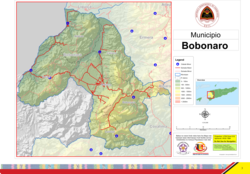
Bobonaro (Portuguese: Município Bobonaro, Tetum: Munisípiu Bobonaru, or Munisípiu Buburnaru) is a municipality (and was formerly a district) in the Democratic Republic of Timor-Leste commonly known as East Timor. It is the second-most western municipality on the east half of the island. It has a population of 92,045 (Census 2010) and an area of 1,376 km2.
- ^ "Sub-national HDI - Area Database - Global Data Lab". hdi.globaldatalab.org. Retrieved 13 September 2018.

