Back বগুড়া সদর উপজেলা Bengali/Bangla বগুড়া সদর উপজিলা BPY Bogra S. CEB Bogra Sadar Spanish بوگراصدار Persian Bogra Sadar French बगुड़ा सदर उपज़िला Hindi Bogra Sadar Italian Богра-Садар Russian ᱵᱚᱜᱩᱲᱟ ᱥᱚᱫᱚᱨ ᱩᱯᱚᱡᱮᱞᱟ SAT
Bogra Sadar
বগুড়া সদর | |
|---|---|
 Gokul Medh, part of Mahasthangarh | |
 | |
| Coordinates: 24°51′N 89°22′E / 24.850°N 89.367°E | |
| Country | |
| Division | Rajshahi |
| District | Bogra |
| Seat | Bogra |
| Area | |
| • Total | 176.58 km2 (68.18 sq mi) |
| Population (2011 census)[1] | |
| • Total | 555,014 |
| • Density | 3,100/km2 (8,100/sq mi) |
| Time zone | UTC+6 (BST) |
| Postal code | 5800, 5801 |
| Website | sadar |
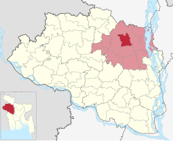
Bogra Sadar Upazila (Bengali: বগুড়া সদর উপজেলা) is an upazila of Bogra District in the Division of Rajshahi, Bangladesh. Bogra Thana was established in 1821 and was converted into an upazila in 1983.[2][3] The upazila takes its name from the district and the Bengali word sadar (headquarters). It is the subdistrict where the district headquarters, Bogra town, is located.
- ^ a b Cite error: The named reference
census2011was invoked but never defined (see the help page). - ^ Haq, Md Nazmul (2012). "Bogra District". In Islam, Sirajul; Jamal, Ahmed A. (eds.). Banglapedia: National Encyclopedia of Bangladesh (Second ed.). Asiatic Society of Bangladesh.
- ^ Cite error: The named reference
Banglapediawas invoked but never defined (see the help page).