| Col. Bonny Serrano Avenue | |
|---|---|
| Santolan Road | |
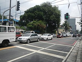
 Bonny Serrano Avenue looking east from 8th Avenue in Cubao | |
| Route information | |
| Maintained by the Department of Public Works and Highways | |
| Length | 4.418 km[1] (2.745 mi) |
| Component highways | |
| Major junctions | |
| West end | P. Guevarra Street / Pinaglabanan Street in San Juan |
| East end | |
| Location | |
| Country | Philippines |
| Major cities | Quezon City and San Juan |
| Highway system | |
| |
Colonel Bonny Serrano Avenue (also spelled Boni Serrano Avenue), formerly named and still colloquially known as and referred to as Santolan Road, is a major east–west thoroughfare in the Eastern Manila District of Metro Manila, Philippines, between San Juan and Quezon City. It forms the northern limit of San Juan and the southern limit of Quezon City's New Manila district. It also links the PNP headquarters in Camp Crame with the AFP headquarters in Camp Aguinaldo. The avenue runs from the border of barangays Corazón de Jesús, St. Joseph (Halo-Halo), Pasadena, and Little Baguio in San Juan to barangays Libís and Blue Ridge B near the Quezon City-Marikina border in the east. It was named after the decorated Korean War hero, Venancio "Bonny" Serrano.[3]
- ^ "Road and Bridge Inventory". Department of Public Works and Highways. Archived from the original on October 22, 2020. Retrieved August 2, 2020.
- ^ "NCR". Department of Public Works and Highways. Retrieved May 25, 2020.
- ^ "Bikol awardees give back to their birthplaces". Philippine Daily Inquirer. Retrieved May 16, 2015.


