Back بوسانسكا كروبا Arabic Босанска Крупа Bulgarian Bosanska Krupa BS Bosanska Krupa Catalan Bosanska Krupa (lungsod sa Bosniya ug Ersogobina) CEB Bosanska Krupa Czech Bosanska Krupa German Μποσάνσκα Κρούπα Greek Bosanska Krupa Spanish بوسانسکا کروپا Persian
Bosanska Krupa
Босанска Крупа | |
|---|---|
| Grad Bosanska Krupa Град Босанска Крупа City of Bosanska Krupa | |
 Top left: Krvsnica Valley in Una Forest Park; top right: Temple of the Nativity of the Holy Virgin (left) and City Mosque; middle right: footbridge in Ade River; bottom left: panorama view from fortress of Bosanska Krupa; bottom right: city view, watermills in Una River | |
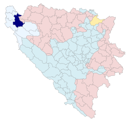
 Location of Bosanska Krupa within Bosnia and Herzegovina. | |
| Coordinates: 44°53′N 16°09′E / 44.883°N 16.150°E | |
| Country | |
| Entity | Federation of Bosnia and Herzegovina |
| Canton | |
| Geographical region | Bosanska Krajina |
| Government | |
| • Mayor | Afan Arnautovic (SDP BiH) |
| Area | |
| • City | 561 km2 (217 sq mi) |
| Population (2013 census) | |
| • City | 25,545 |
| • Density | 643/km2 (1,670/sq mi) |
| • Urban | 10,196 |
| Time zone | UTC+1 (CET) |
| • Summer (DST) | UTC+2 (CEST) |
| Area code | +387 37 |
Bosanska Krupa (Serbian Cyrillic: Босанска Крупа) is a city located in the Una-Sana Canton of the Federation of Bosnia and Herzegovina, an entity of Bosnia and Herzegovina. As of 2013, it has a population of 29,659 inhabitants.
It is situated on the banks of river Una in northwestern Bosnia and Herzegovina, 30 km (19 mi) northeast from Bihać (350 km away from Sarajevo).
