Back بومانستاون (بنسيلفانيا) Arabic Бовменстаун (Пенсильвани) CE Bowmanstown CEB Bowmanstown, Pennsylvania Welsh Bowmanstown Spanish Bowmanstown (Pennsylvania) Basque Bowmanstown French Bowmanstown, Pennsilvani HT Bowmanstown Italian Bowmanstown (Pennsylvania) LLD
Bowmanstown, Pennsylvania | |
|---|---|
Borough | |
 | |
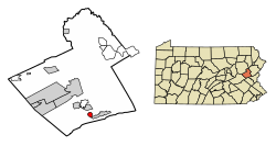
 Location of Bowmanstown in Carbon County, Pennsylvania | |
| Coordinates: 40°48′03″N 75°39′44″W / 40.80083°N 75.66222°W | |
| Country | United States |
| State | Pennsylvania |
| County | Carbon |
| Area | |
| • Total | 0.80 sq mi (2.07 km2) |
| • Land | 0.77 sq mi (1.99 km2) |
| • Water | 0.03 sq mi (0.07 km2) |
| Elevation | 732 ft (223 m) |
| Population | |
| • Total | 889 |
| • Density | 1,156.05/sq mi (446.19/km2) |
| Time zone | UTC-5 (EST) |
| • Summer (DST) | UTC-4 (EDT) |
| ZIP code | 18030 |
| Area code(s) | 610 and 484 |
| FIPS code | 42-07880 |
Bowmanstown is a borough in Carbon County, Pennsylvania. It is part of Northeastern Pennsylvania. The population was 937 at the 2010 census.[3]
The borough is at an elevation of 437 feet (133 m). It is located 3 miles (5 km) west of Palmerton and 4 miles (6 km) south of Lehighton off Pennsylvania Route 248.
- ^ "ArcGIS REST Services Directory". United States Census Bureau. Retrieved October 12, 2022.
- ^ Cite error: The named reference
USCensusDecennial2020CenPopScriptOnlywas invoked but never defined (see the help page). - ^ "Geographic Identifiers: 2010 Demographic Profile Data (G001): Bowmanstown borough, Pennsylvania". U.S. Census Bureau, American Factfinder. Archived from the original on February 13, 2020. Retrieved April 1, 2015.


