Back جبل برايرياتش ARZ Braeriach CEB Braeriach Welsh Braeriach German Braeriach Spanish Braeriach Basque Braeriach French Am Bràigh Riabhach Irish Am Bràigh Riabhach Scots/Gaelic Braeriach LLD
| Braeriach | |
|---|---|
| Am Bràigh Riabhach | |
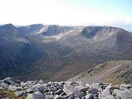
 Braeriach from the southeast | |
| Highest point | |
| Elevation | 1,296 m (4,252 ft)[1] |
| Prominence | 461 m (1,512 ft) |
| Parent peak | Ben Macdui |
| Listing | Marilyn, Munro |
| Naming | |
| English translation | The brindled upland |
| Language of name | Gaelic |
| Pronunciation | Scottish Gaelic: [əm ˈpɾaːj ˈrˠiəvəx] |
| Geography | |
| OS grid | NN953999 |
| Topo map | OS Landranger 36, 43 |
| Name | Grid ref | Height | Status |
|---|---|---|---|
| Braeriach | NN953999 | 1296 m | Munro, Marilyn |
| Carn na Criche | NN939982 | 1265 m | Munro Top |
| Sròn na Lairige | NH964006 | 1184 m | Munro Top |
Braeriach or Brae Riach (Scottish Gaelic: Am Bràigh Riabhach, 'the brindled upland')[2] is the third-highest mountain in Scotland and all of the British Isles, after Ben Nevis and Ben Macdui, rising 1,296 metres (4,252 ft) above sea level. It is in the Scottish Highlands and is the highest point in the western massif of the Cairngorms, separated from the central section by the Lairig Ghru pass. The summit is a crescent-shaped plateau, overlooking several corries.
Probably the most commonly used route up Braeriach starts from Sugar Bowl car park, on the road leading to the Cairn Gorm ski area. From here a path leads over the hillside to a steep-sided rocky ravine known as the Chalamain Gap, before descending around 100 metres (330 ft) to the Lairig Ghru. After crossing this pass the route heads for the summit via Braeriach's north ridge, crossing a subsidiary peak, Sròn na Lairige. The summit is about 9 km (5.6 mi) from the car park by this route.
- ^ "Braeriach". Hill Bagging - the online version of the Database of British and Irish Hills (DoBIH). 2019. Retrieved 19 June 2019.
- ^ "Braeriach". Ainmean-Àite na h-Alba: Gaelic Place-Names of Scotland.
