Back Braidwood (lungsod sa Ostralya) CEB Braidwood (Nueva Gales del Sur) Spanish برایدوود، نیو ساوت ولز Persian Braidwood French Braidwood, New South Wales ID Braidwood (Australia) Polish Braidwood, New South Wales SIMPLE Braidwood, Australien Swedish
| Braidwood New South Wales | |||||||||||||||
|---|---|---|---|---|---|---|---|---|---|---|---|---|---|---|---|
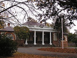
 The Braidwood Courthouse, built in 1901 | |||||||||||||||
| Coordinates | 35°26′0″S 149°48′0″E / 35.43333°S 149.80000°E | ||||||||||||||
| Population | 1,720 (2021 census)[1] | ||||||||||||||
| Postcode(s) | 2622 | ||||||||||||||
| Elevation | 643 m (2,110 ft) | ||||||||||||||
| Location |
| ||||||||||||||
| LGA(s) | Queanbeyan–Palerang Regional Council | ||||||||||||||
| Region | Southern Tablelands | ||||||||||||||
| County | St Vincent | ||||||||||||||
| Parish | Braidwood | ||||||||||||||
| State electorate(s) | Monaro | ||||||||||||||
| Federal division(s) | Eden-Monaro | ||||||||||||||
| |||||||||||||||
| |||||||||||||||
Braidwood is a town in the Southern Tablelands of New South Wales, Australia, in Queanbeyan–Palerang Regional Council.[2][3] It is located on the Kings Highway linking Canberra with Batemans Bay. It is approximately 200 kilometres south west of Sydney, 60 kilometres inland from the coast, and 55 kilometres east of Canberra. Braidwood is a service town for the surrounding district which is based on sheep and cattle grazing, and forestry operations.
- ^ Cite error: The named reference
ABSwas invoked but never defined (see the help page). - ^ "Braidwood". Geographical Names Register (GNR) of NSW. Geographical Names Board of New South Wales. Retrieved 2 November 2017.
- ^ "Braidwood". OpenStreetMap. Retrieved 2 November 2017.
