Back نهر بروكن (فيكتوريا) Arabic بروكين ريفير ARZ Broken River (suba) CEB Broken River (Goulburn River) German Rivero Broken (Viktorio) Esperanto Broken River (Victoria) NB Broken River, Victoria Swedish
| Broken Dareterkornong | |
|---|---|
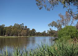
 A weir constructed across the Broken River formed Lake Benalla | |
 | |
| Location | |
| Country | Australia |
| State | Victoria |
| Region | Alpine and Riverine bioregions (IBRA), Victorian Alps, Northern Country/North Central |
| Local government areas | Mansfield, Benalla, Greater Shepparton |
| Towns and cities | Benalla, Shepparton–Mooroopna |
| Physical characteristics | |
| Source | Victorian Alps, Great Dividing Range |
| • location | near Bald Hill |
| • coordinates | 36°44′03″S 146°19′20″E / 36.73417°S 146.32222°E |
| • elevation | 1,190 m (3,900 ft) |
| Mouth | confluence with the Goulburn River |
• location | near Shepparton |
• coordinates | 36°23′39″S 145°23′3″E / 36.39417°S 145.38417°E |
• elevation | 115 m (377 ft) |
| Length | 225 km (140 mi) |
| Discharge | |
| • average | 9 m3/s (320 cu ft/s) |
| Basin features | |
| River system | Goulburn Broken catchment, Murray–Darling basin |
| [1] | |
The Broken River, a minor inland perennial river of the Goulburn Broken catchment, part of the Murray–Darling basin, is located in the Alpine and Northern Country/North Central regions of the Australian state of Victoria. The headwaters of the Broken River rise in the western slopes of the Victorian Alps, near Bald Hill and descend to flow into the Goulburn River near Shepparton. The river is impounded by the Nillahcootie Dam to create Lake Nillahcootie and Benalla Dam to create Lake Benalla.
- ^ "Map of Broken River". Bonzle Digital Atlas of Australia. Retrieved 12 July 2014.