Back مقاطعة براون (كانساس) Arabic Brown County, Kansas BAR Браун (окръг, Канзас) Bulgarian ব্রাউন কাউন্টি, ক্যানসাস BPY Brown Gông (Kansas) CDO Браун (гуо, Канзас) CE Brown County (kondado sa Tinipong Bansa, Kansas) CEB Brown County (Kansas) Czech Brown County, Kansas Welsh Brown County (Kansas) German
Brown County | |
|---|---|
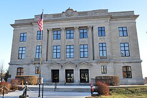
 Brown County Courthouse in Hiawatha (2011) | |
 Location within the U.S. state of Kansas | |
 Kansas's location within the U.S. | |
| Coordinates: 39°48′N 95°35′W / 39.800°N 95.583°W | |
| Country | |
| State | |
| Founded | August 25, 1855 |
| Named for | Albert Gallatin Brown |
| Seat | Hiawatha |
| Largest city | Hiawatha |
| Area | |
| • Total | 572 sq mi (1,480 km2) |
| • Land | 571 sq mi (1,480 km2) |
| • Water | 1.2 sq mi (3 km2) 0.2% |
| Population | |
| • Total | 9,508 |
| • Estimate (2023)[2] | 9,250 |
| • Density | 16.7/sq mi (6.4/km2) |
| Time zone | UTC−6 (Central) |
| • Summer (DST) | UTC−5 (CDT) |
| Area code | 785 |
| Congressional district | 2nd |
| Website | brcoks.org |
Brown County is a county located in the northeast portion of the U.S. state of Kansas. Its county seat and most populous city is Hiawatha.[3] As of the 2020 census, the county population was 9,508.[1] The county was named after Albert G. Brown, a U.S. Senator from Mississippi and Kansas statehood advocate. The Kickapoo Indian Reservation of Kansas, the majority of the Sac and Fox Reservation, and the majority of the Iowa Reservation of Kansas and Nebraska are located within the county.
- ^ a b "QuickFacts; Brown County, Kansas; Population, Census, 2020 & 2010". United States Census Bureau. Archived from the original on August 15, 2021. Retrieved August 15, 2021.
- ^ "Annual Estimates of the Resident Population for Counties: April 1, 2020 to July 1, 2023". United States Census Bureau. Retrieved March 24, 2024.
- ^ "Find a County". National Association of Counties. Archived from the original on May 31, 2011. Retrieved June 7, 2011.