Back خليج بروناي Arabic Badea de Brunéi AST Brunei Bay (luuk sa Malaysiya) CEB Bucht von Brunei German Bahía de Brunéi Spanish Baie de Brunei French Teluk Brunei ID ブルネイ湾 Japanese 브루나이만 Korean Brunėjaus įlanka Lithuanian
| Brunei Bay Teluk Brunei | |
|---|---|
 Brunei Bay from space | |
| Location | Southeast Asia |
| Coordinates | 5°00′43.44″N 115°17′26.66″E / 5.0120667°N 115.2907389°E |
| Type | Bay |
| Primary inflows | South China Sea |
| Basin countries | Brunei, Malaysia |
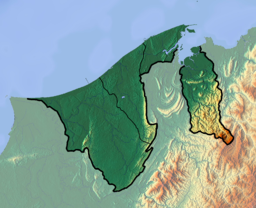
Brunei Bay (Malay: Teluk Brunei) is on the northwestern coast of Borneo island, in Brunei and Malaysia. It is located east of Bandar Seri Begawan, Brunei.
It is the ocean gateway to the isolated Temburong District of Brunei, separated from the rest of Brunei by the Malaysian Sarawak State surrounding it to the bay.
A 30-kilometre (19 mi) roadway connecting the Muara and Temburong districts of Brunei, completed in 2018, crosses over the Brunei bay. The section going across the Brunei bay measures in at 14-kilometre (8.7 mi).[1]
- ^ Rabiatul, Kamit (10 May 2013). "Temburong bridge ready 2018". Brunei Times. Archived from the original on 2013-12-03. Retrieved 10 July 2013.
