Back بروكسل (ويسكونسن) Arabic Брасселс (Висконсин) CE Brussels (Wisconsin) Spanish Brussels (Wisconsin) French Brussels, Wisconsin HT Brussels (Wisconsin) Italian Brussels (Wisconsin) Polish Брасселс (Висконсин) Tatar Брасселс (Вісконсин) Ukrainian Brussels, Wisconsin Vietnamese
Brussels, Wisconsin | |
|---|---|
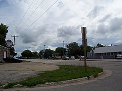
 Looking east at Brussels on WIS 57 | |
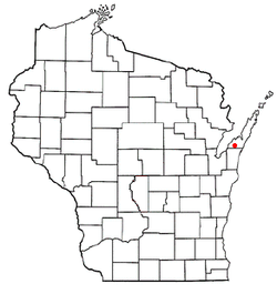
 Location of Brussels, Wisconsin | |
| Coordinates: 44°43′54″N 87°34′45″W / 44.73167°N 87.57917°W | |
| Country | United States |
| State | Wisconsin |
| County | Door |
| Area | |
| • Total | 36.1 sq mi (93.6 km2) |
| • Land | 36.1 sq mi (93.6 km2) |
| • Water | 0.0 sq mi (0.0 km2) |
| Elevation | 722 ft (220 m) |
| Population (2020) | |
| • Total | 1,125 |
| • Density | 30.8/sq mi (11.9/km2) |
| Time zone | UTC-6 (Central (CST)) |
| • Summer (DST) | UTC-5 (CDT) |
| Area code | 920 |
| FIPS code | 55-10700[2] |
| GNIS feature ID | 1582880[1] |
| Website | http://www.townofbrussels.com/ |
Brussels is a town in Door County, Wisconsin, United States. The population was 1,136 at the 2010 census. The unincorporated communities of Brussels, Misere, and Kolberg are located in the town. The unincorporated community of Rosiere is also located partially in the town.[3]
- ^ a b "US Board on Geographic Names". United States Geological Survey. October 25, 2007. Retrieved January 31, 2008.
- ^ "U.S. Census website". United States Census Bureau. Retrieved January 31, 2008.
- ^ Map of the Town of Brussels, Door County Land Use Services Department, August 16, 2017 (Archived April 9, 2019)