Back برايس كانيون Arabic متنزه برايس كانيون الوطنى ARZ Parque nacional del Cañón Bryce AST Брайс-Каньон (милли парк) Bashkir Taman Nasional Bryce Canyon BAN Брайс каньон Bulgarian Parc Nacional del Canyó Bryce Catalan Bryce Canyon National Park CEB Národní park Bryce Canyon Czech Bryce Canyon National Park Danish
This article needs additional citations for verification. (May 2024) |
| Bryce Canyon National Park | |
|---|---|
 | |
| Location | Garfield County and Kane County, Utah, United States |
| Nearest city | Tropic, Panguitch |
| Coordinates | 37°38′N 112°10′W / 37.64°N 112.17°W |
| Area | 35,835 acres (145.02 km2)[1] |
| Established | February 25, 1928 |
| Visitors | 2,354,660 (in 2022)[2] |
| Governing body | National Park Service |
| Website | nps |
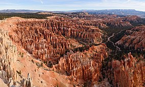
Bryce Canyon National Park (/braɪs/) is a national park of the United States located in southwestern Utah. The major feature of the park is Bryce Canyon, which despite its name, is not a canyon, but a collection of giant natural amphitheaters along the eastern side of the Paunsaugunt Plateau. Bryce is distinctive due to geological structures called hoodoos, formed by frost weathering and stream erosion of the river and lake bed sedimentary rock. The red, orange, and white colors of the rocks provide spectacular views for park visitors. Bryce Canyon National Park is much smaller and sits at a much higher elevation than nearby Zion National Park. The rim at Bryce varies from 8,000 to 9,000 feet (2,400 to 2,700 m).
The area is in portions of Garfield County[3] and Kane County.[4]
The Bryce Canyon area was settled by Mormon pioneers in the 1850s and was named after Ebenezer Bryce, who homesteaded in the area in 1874.[5] The area was originally designated as a national monument by President Warren G. Harding in 1923 and was redesignated as a national park by Congress in 1928. The park covers 35,835 acres (55.992 sq mi; 14,502 ha; 145.02 km2)[1] and receives substantially fewer visitors than Zion National Park (nearly 4.3 million in 2016) or Grand Canyon National Park (almost 6 million in 2016), largely due to Bryce's more remote location. In 2023, Bryce Canyon received 2,461,269.[2]
- ^ a b "Listing of acreage – December 31, 2011" (XLSX). Land Resource Division, National Park Service. Retrieved March 6, 2012. (National Park Service Acreage Reports)
- ^ a b "NPS Annual Recreation Visits Report". National Park Service. Retrieved July 23, 2023.
- ^ "2020 CENSUS - CENSUS BLOCK MAP: Garfield County, UT" (PDF). U.S. Census Bureau. p. 35 (PDF p. 34/47). Retrieved September 28, 2024.
- ^ "2020 CENSUS - CENSUS BLOCK MAP: Kane County, UT" (PDF). U.S. Census Bureau. p. 4 (PDF pp. 5/54). Retrieved September 28, 2024.
- ^ Kiver 1999, p. 523

