Back Buffalo National River CEB رودخانه ملی بوفالو Persian Buffalo National River French ബഫലോ ദേശീയ നദി Malayalam
| Buffalo National River | |
|---|---|
 Buffalo National River, Arkansas | |
 | |
| Physical characteristics | |
| Length | 153 miles (246 km) |
| Discharge | |
| • location | Harriet, AR |
| • average | 1,355 cu. ft. per sec.[1] |
| Type | Wild, Scenic |
| Designated | April 22, 1992 |

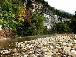
The Buffalo National River, in Northern Arkansas, was the first National River to be designated in the United States. The Buffalo River is 153 miles (246 km) long. The lower 135 miles (217 km) flow within the boundaries of an area managed by the National Park Service, where the stream is designated the Buffalo National River.[2] The river flows through Newton, Searcy, Marion, and Baxter Counties, from west to east. The river originates in the highest part of the Boston Mountains of the Ozarks, flows out onto the Springfield Plateau near the historic community of Erbie, and finally crosses a portion of the Salem Plateau just before joining the White River. The Park is home to the state's only elk herd. The upper section of the river in the Ozark National Forest is managed by the U.S. Forest Service and is designated as a National Scenic River and a National Wild River.
- ^ "USGS Current Conditions for USGS 07056700 Buffalo River near Harriet, AR".
- ^ "Buffalo National River". National Park Service. January 16, 2013. Retrieved February 9, 2013.