Back مقاطعة بولوك (ألاباما) Arabic Ballok qraflığı (Alabama) Azerbaijani Bullock County, Alabama BAR Бълок (окръг, Алабама) Bulgarian বাল্লক কাউন্টি, আলাবামা BPY Bullock Gông (Alabama) CDO Буллок (гуо, Алабама) CE Bullock County CEB Bullock County Czech Bullock County, Alabama Welsh
Bullock County | |
|---|---|
 Bullock County courthouse in Union Springs | |
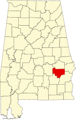
 Location within the U.S. state of Alabama | |
 Alabama's location within the U.S. | |
| Coordinates: 32°05′52″N 85°43′02″W / 32.0978°N 85.7172°W | |
| Country | |
| State | |
| Founded | December 5 (created), 1866 |
| Named for | Edward Bullock |
| Seat | Union Springs |
| Largest city | Union Springs |
| Area | |
| • Total | 625 sq mi (1,620 km2) |
| • Land | 623 sq mi (1,610 km2) |
| • Water | 2.3 sq mi (6 km2) 0.4% |
| Population (2020) | |
| • Total | 10,357 |
| • Estimate (2023) | 9,897 |
| • Density | 17/sq mi (6.4/km2) |
| Time zone | UTC−6 (Central) |
| • Summer (DST) | UTC−5 (CDT) |
| Congressional district | 2nd |
| Website | bullockcountyalrev |
| |
Bullock County is a county of the U.S. state of Alabama. As of the 2020 census, the population was 10,357.[1] Union Springs was chosen as the county seat in 1867, and presently is the county's only incorporated city.[2] The county was named for Confederate Army Colonel Edward C. Bullock who was a state senator and outspoken secessionist who died during the American Civil War.[3]
A National Center for Education Statistics report released in January 2009 showed that Bullock County had the highest illiteracy rate in Alabama at 34 percent.[4]
- ^ "State & County QuickFacts". United States Census Bureau. Retrieved September 9, 2023.
- ^ "Find a County". National Association of Counties. Archived from the original on May 31, 2011. Retrieved June 7, 2011.
- ^ "Bullock County, Alabama History, ADAH". Alabama Department of Archives and History. Retrieved June 12, 2019.
- ^ The Associated Press (January 8, 2009). "Study finds Alabama literacy rate improved, Shelby County has state's lowest illiteracy". AL.com.

