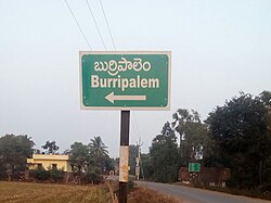
Burripalem | |
|---|---|
 Burripalem signboard | |
 Dynamic map | |
| Coordinates: 16°15′N 80°35′E / 16.25°N 80.58°E | |
| Country | India |
| State | Andhra Pradesh |
| District | Guntur |
| Seat | Burripalem Gram Panchayat |
| Wards | 12 |
| Government | |
| • Type | Panchayati raj |
| • Body | Burripalem Gram Sabha |
| • Sarpanch | Vacant |
| Area | |
| • Total | 7.02 km2 (2.71 sq mi) |
| Elevation | 10 m (30 ft) |
| Population (2011)[4] | |
| • Total | 3,306 |
| • Density | 470/km2 (1,200/sq mi) |
| Languages | |
| • Official | Telugu |
| Time zone | UTC+5:30 (IST) |
| PIN | 522 xxx |
| Telephone code | 08644 |
Burripalem is an area of Tenali in Guntur district of the Indian state of Andhra Pradesh. It is located in Tenali, Tenali mandal of Tenali revenue division.[2] It forms a part of Andhra Pradesh Capital Region.[5]
- ^ "Gram Panchayat Identification Codes" (PDF). Saakshar Bharat Mission. National Informatics Centre. p. 120. Archived from the original (PDF) on 18 August 2017. Retrieved 7 May 2019.
- ^ a b "District Census Handbook : Guntur" (PDF). Census of India. p. 14,408. Retrieved 22 September 2015.
- ^ "Elevation for Rajam". Veloroutes. Retrieved 4 November 2014.
- ^ "Census 2011". The Registrar General & Census Commissioner, India. Retrieved 3 September 2014.
- ^ "Declaration of A.P. Capital Region" (PDF). Andhra Pradesh Capital Region Development Authority. Municipal Administration and Urban Development Department, Andhra Pradesh. 30 December 2014. p. 4. Archived from the original (PDF) on 11 May 2019. Retrieved 17 May 2019.


