Back Burwood (Nueva Gales del Sur) Spanish بروود، نیو ساوت ولز Persian Burwood (Nouvelle-Galles du Sud) French Burwood, New South Wales ID Burwood (Sydney) Polish Burwood, New South Wales Romanian Бервуд (Сидней) Russian برووڈ، نیوساؤتھ ویلز Urdu 宝活 (新南威尔士州) Chinese
| Burwood Sydney, New South Wales | |||||||||||||||
|---|---|---|---|---|---|---|---|---|---|---|---|---|---|---|---|
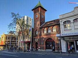
 Burwood Road and part of the heritage-listed Burwood Post Office, designed by Walter Liberty Vernon. | |||||||||||||||
 | |||||||||||||||
| Population | 18,224 (2021 census)[1] | ||||||||||||||
| • Density | 9,100/km2 (24,000/sq mi) | ||||||||||||||
| Established | 1814 | ||||||||||||||
| Postcode(s) | 2134 | ||||||||||||||
| Elevation | 30 m (98 ft) | ||||||||||||||
| Area | 2 km2 (0.8 sq mi) | ||||||||||||||
| Location | 10 km (6 mi) west of Sydney CBD | ||||||||||||||
| LGA(s) | Municipality of Burwood | ||||||||||||||
| State electorate(s) | Strathfield | ||||||||||||||
| Federal division(s) | Reid | ||||||||||||||
| |||||||||||||||
Burwood is an affluent[2] suburb in the Inner West[3] of Sydney, in the state of New South Wales, Australia. It is 10 kilometres (6.2 mi) west of the Sydney central business district and is the administrative centre for the local government area of Municipality of Burwood.
Burwood Heights is a separate suburb to the south. The Appian Way is a street in Burwood, known for its architecturally designed Federation-style homes.
- ^ Australian Bureau of Statistics (28 June 2022). "Burwood (NSW) (State Suburb)". 2021 Census QuickStats. Retrieved 28 June 2022.
- ^ Williams, Sue (12 August 2024). "The unassuming Sydney suburb where the median house price has soared to $3 million". domain.co.au. Retrieved 10 November 2024.
{{cite web}}: CS1 maint: url-status (link) - ^ Australian Suburb Guide: Sydney Inner West Archived 26 December 2012 at the Wayback Machine Retrieved 7 August 2013.