| Burwood East Melbourne, Victoria | |||||||||||||||
|---|---|---|---|---|---|---|---|---|---|---|---|---|---|---|---|
 Robinson Drive, Burwood East | |||||||||||||||
 | |||||||||||||||
| Coordinates | 37°51′07″S 145°09′00″E / 37.852°S 145.15°E | ||||||||||||||
| Population | 10,675 (SAL 2021)[1] | ||||||||||||||
| Postcode(s) | 3151 | ||||||||||||||
| Elevation | 125 m (410 ft) | ||||||||||||||
| Area | 4.3 km2 (1.7 sq mi) | ||||||||||||||
| Location | 17 km (11 mi) from Melbourne | ||||||||||||||
| LGA(s) | City of Whitehorse | ||||||||||||||
| State electorate(s) | |||||||||||||||
| Federal division(s) | Chisholm | ||||||||||||||
| |||||||||||||||

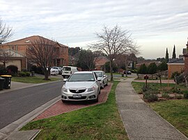
Burwood East is a suburb of Melbourne, Victoria, Australia, located 17 km (11 mi) east of Melbourne's Central Business District,[2] located within the City of Whitehorse local government area. Burwood East recorded a population of 10,675 at the 2021 census.[3]
Burwood East is bounded by Springvale Road to the east, Middleborough Road to the west, Eley Road and Hawthorn Road to the north and Highbury Road to the south.
- ^ Australian Bureau of Statistics (28 June 2022). "Burwood East (suburb and locality)". Australian Census 2021 QuickStats. Retrieved 28 June 2022.
- ^ "Postcode for Burwood East, Victoria (Near Melbourne) - Postcodes Australia".
- ^ "2021 Census QuickStats Burwood East". Australian Bureau of Statistics. Retrieved 3 July 2022.

