Back Byers (punta) CEB Byers-Halbinsel German Península Byers Spanish חצי האי ביירז HE Penisola Byers Italian Byers Peninsula NN Byers Peninsula Polish Byers Peninsula Swedish 拜爾斯半島 Chinese


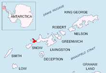
Byers Peninsula is a mainly ice-free peninsula forming the west end of Livingston Island in the South Shetland Islands of Antarctica. It occupies 60 km2 (23 sq mi),[1] borders Ivanov Beach to the northeast and is separated from Rotch Dome on the east by the ridge of Urvich Wall. The peninsula features more than 60 meltwater streams and as many lakes, notably Midge Lake, Limnopolar Lake and Basalt Lake.[2] Byers Peninsula has a regime of special environmental protection under the Antarctic Treaty System and requires a permit to enter.[3]
- ^ L.L. Ivanov. Antarctica: Livingston Island and Greenwich, Robert, Snow and Smith Islands. Scale 1:120000 topographic map. Troyan: Manfred Wörner Foundation, 2010. ISBN 978-954-92032-9-5 (First edition 2009. ISBN 978-954-92032-6-4)
- ^ Cite error: The named reference
ivanovwas invoked but never defined (see the help page). - ^ Management Plan for Antarctic Specially Protected Area No. 126 Byers Peninsula, Livingston Island, South Shetland Islands. Archived 2010-07-06 at the Wayback Machine SCAR Bulletin 150, July 2003.