Back مقاطعة كابيل (فرجينيا الغربية) Arabic Cabell County, West Virginia BAR Кабъл (окръг, Западна Вирджиния) Bulgarian কাবেল কাউন্টি, ৱেস্ট ভার্জিনিয়া BPY Cabell Gông (West Virginia) CDO Кабелл (гуо, Малхбузен Виргини) CE Cabell County CEB Cabell County, Gorllewin Virginia Welsh Cabell County German Kantono Cabell Esperanto
Cabell County | |
|---|---|
 | |
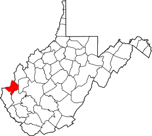
 Location within the U.S. state of West Virginia | |
 West Virginia's location within the U.S. | |
| Coordinates: 38°25′N 82°14′W / 38.42°N 82.24°W | |
| Country | |
| State | |
| Founded | January 2, 1809 |
| Named for | William H. Cabell |
| Seat | Huntington |
| Largest city | Huntington |
| Area | |
| • Total | 288 sq mi (750 km2) |
| • Land | 281 sq mi (730 km2) |
| • Water | 7.0 sq mi (18 km2) 2.4% |
| Population (2020) | |
| • Total | 94,350 |
| • Estimate (2021) | 93,418 |
| • Density | 330/sq mi (130/km2) |
| Time zone | UTC−5 (Eastern) |
| • Summer (DST) | UTC−4 (EDT) |
| Congressional district | 1st |
| Website | www |
Cabell County is a county located in the U.S. state of West Virginia. As of the 2020 census, the population was 94,350,[1] making it West Virginia's fourth most-populous county. Its county seat is Huntington.[2] The county was organized in 1809 and named for William H. Cabell, the Governor of Virginia from 1805 to 1808.[3] Cabell County is part of the Huntington–Ashland, WV–KY–OH Metropolitan Statistical Area.
- ^ "State & County QuickFacts". United States Census Bureau. Retrieved July 6, 2022.
- ^ "Find a County". National Association of Counties. Archived from the original on May 31, 2011. Retrieved June 7, 2011.
- ^ "Cabell County history sources". wvculture.org. Archived from the original on October 29, 2015. Retrieved March 8, 2017.