Back مقاطعة كالهاون (إلينوي) Arabic Calhoun County, Illinois BAR Калхун (окръг, Илинойс) Bulgarian কলহৌন কাউন্টি, ইলিনয়স BPY Calhoun Gông (Illinois) CDO Калхун (гуо, Иллинойс) CE Calhoun County (kondado sa Tinipong Bansa, Illinois) CEB Calhoun County, Illinois Welsh Calhoun County (Illinois) German Κομητεία Κάλχουν (Ιλινόι) Greek
Calhoun County | |
|---|---|
 Calhoun County Courthouse in Hardin | |
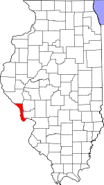
 Location within the U.S. state of Illinois | |
 Illinois's location within the U.S. | |
| Coordinates: 39°10′N 90°40′W / 39.16°N 90.67°W | |
| Country | |
| State | |
| Founded | 1825 |
| Named for | John C. Calhoun |
| Seat | Hardin |
| Largest village | Hardin |
| Area | |
| • Total | 284 sq mi (740 km2) |
| • Land | 254 sq mi (660 km2) |
| • Water | 30 sq mi (80 km2) 10.5% |
| Population (2020) | |
| • Total | 4,437 |
| • Density | 16/sq mi (6.0/km2) |
| Time zone | UTC−6 (Central) |
| • Summer (DST) | UTC−5 (CDT) |
| Congressional district | 15th |
Calhoun County is a county in the U.S. state of Illinois. As of the 2020 census, the population was 4,437,[1] making it Illinois’ third-least populous county. Its county seat and biggest community is Hardin, with a population of 801.[2] Its smallest incorporated community is Hamburg, with a population of 99. Calhoun County is at the tip of the peninsula formed by the courses of the Mississippi and Illinois rivers above their confluence and is almost completely surrounded by water. Calhoun County is sparsely populated; it has just five municipalities, all of them villages.[3]
Calhoun County is part of the Metro-East portion of the St. Louis, MO-IL Metropolitan Statistical Area.
- ^ "Calhoun County, Illinois". United States Census Bureau. Archived from the original on October 5, 2024. Retrieved June 8, 2023.
- ^ "Find a County". National Association of Counties. Archived from the original on May 31, 2011. Retrieved June 7, 2011.
- ^ "Visitors Guide to Calhoun County". greatriverroad.com. Archived from the original on July 7, 2012. Retrieved August 11, 2012.