Back کامبورن AZB Камборн Bulgarian Kammbronn Breton Camborne (lungsod) CEB Camborne Czech Camborne Welsh Camborne German Camborne Spanish Camborne Basque کامبورن Persian
| Camborne | |
|---|---|
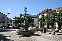
 Commercial Square, Camborne Town Centre | |
Location within Cornwall | |
| Population | 21,600 (2013) |
| OS grid reference | SW645400 |
| Civil parish |
|
| Unitary authority | |
| Ceremonial county | |
| Region | |
| Country | England |
| Sovereign state | United Kingdom |
| Post town | CAMBORNE |
| Postcode district | TR14 |
| Dialling code | 01209 |
| Police | Devon and Cornwall |
| Fire | Cornwall |
| Ambulance | South Western |
| UK Parliament | |
Camborne (from Cornish Cambron, "crooked hill")[1] is a town in Cornwall, England.[2][3] The population at the 2011 Census was 20,845.[4][5][6] The northern edge of the parish includes a section of the South West Coast Path, Hell's Mouth and Deadman's Cove.
Camborne was formerly one of the richest tin mining areas in the world and home to the Camborne School of Mines.
- ^ Watts, Victor, ed. (2010). The Cambridge Dictionary of English Place-Names. Cambridge University Press. p. 111. ISBN 978-0-521-16855-7.
- ^ Chisholm, Hugh, ed. (1911). . Encyclopædia Britannica (11th ed.). Cambridge University Press.
- ^ Ordnance Survey: Landranger map sheet 203 Land's End ISBN 978-0-319-23148-7
- ^ Office for National Statistics, Key Figures for 2011 Census: Key Statistics, Area: Camborne parish
- ^ "Data from the 2011 Census (Office for National Statistics)". Cornwall Council. Retrieved 15 November 2013.
- ^ Cornwall; Explore Britain
