Back Canaigh Breton Canna (Hèbrides Interiors) Catalan Canna, Scotland CEB Canna (ostrov) Czech Canna German Κάννα (νησί) Greek Canna (Escocia) Spanish Canna (uhartea) Basque Canna Finnish Canna (Écosse) French
| Scottish Gaelic name | Canaigh, Eilean Chanaigh |
|---|---|
| Pronunciation | [ˈkʰanaj] , [ˈelan ˈxanaj] |
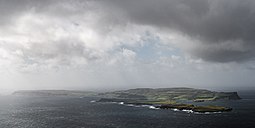
 Isle of Canna, viewed from Rum | |
| Location | |
| OS grid reference | NG244058 |
| Coordinates | 57°04′N 6°33′W / 57.06°N 6.55°W |
| Physical geography | |
| Island group | Small Isles |
| Area | 1,130 hectares (4.4 sq mi) |
| Area rank | 46 [1] |
| Highest elevation | Càrn a' Ghaill 210 metres (689 ft) |
| Administration | |
| Council area | Highland |
| Country | Scotland |
| Sovereign state | United Kingdom |
| Demographics | |
| Population | 15[2](October 2021) |
| Population rank | 67 [1] |
| Population density | 1 person/km2[3][4] |
| References | [4][5] |
 Isle of Canna Small automatic lighthouse on the eastern tip of Sanday | |
 | |
| Location | Isle of Sanday Highland Scotland United Kingdom |
|---|---|
| Coordinates | 57°02′50″N 6°27′57″W / 57.0471°N 6.4659°W |
| Tower | |
| Constructed | 1907 |
| Construction | metal tower |
| Height | 9 metres (30 ft) |
| Shape | cylindrical tower with balcony and lantern |
| Markings | white tower and lantern |
| Power source | solar power |
| Operator | Northern Lighthouse Board[6] |
| Light | |
| Focal height | 32 metres (105 ft) |
| Range | 9 nmi (17 km; 10 mi) |
| Characteristic | Fl W 6s. |
Canna (/ˈkænə/; Scottish Gaelic: Canaigh, Eilean Chanaigh) is the westernmost of the Small Isles archipelago, in the Scottish Inner Hebrides. It is linked to the neighbouring island of Sanday by a road and sandbanks at low tide. The island is 4.3 miles (6.9 km) long and 1 mile (1.6 km) wide. The isolated skerries of Hyskeir and Humla lie 6.2 miles (10.0 km) south-west of the island.[4]
The islands were left to the National Trust for Scotland by their previous owners, the highly important Celtic studies scholars John Lorne Campbell and Margaret Fay Shaw, in 1981, and are run as a farm and conservation area. Canna House, one of two big houses on the island (the other being Tighard), contains Shaw and Campbell's important archives of Scottish Gaelic literature, folklore, and folk song materials that were donated with the islands to the nation.[4] Since then the National Trust has engaged in new initiatives to attract new residents and visitors to Canna. However, these initiatives have enjoyed only limited success, and in December 2017 it was announced that the trust would be devolving to the island community the responsibility for attracting and retaining new residents.[7]
- ^ a b Area and population ranks: there are c. 300 islands over 20 ha in extent and 93 permanently inhabited islands were listed in the 2011 census.
- ^ Development Plan from https://www.theisleofcanna.com/ioccdt
- ^ National Records of Scotland (15 August 2013). "Appendix 2: Population and households on Scotland's Inhabited Islands" (PDF). Statistical Bulletin: 2011 Census: First Results on Population and Household Estimates for Scotland Release 1C (Part Two) (PDF) (Report). SG/2013/126. Retrieved 14 August 2020.
- ^ a b c d Haswell-Smith (2004) pp. 143-46
- ^ Ordnance Survey. OS Maps Online (Map). 1:25,000. Leisure.
- ^ Rowlett, Russ. "Lighthouses of Scotland: Highlands". The Lighthouse Directory. University of North Carolina at Chapel Hill. Retrieved 22 May 2016.
- ^ Wade, Mike (29 December 2017). "National Trust gives island of Canna's 15 residents control of their own destiny". Retrieved 13 June 2019 – via www.thetimes.co.uk.
