Back Canterbury (bahin nga lungsod sa Ostralya, State of Victoria, Boroondara) CEB Canterbury (Melbourne) German کنتربری (ویکتوریا) Persian Canterbury, Bhictòria Scots/Gaelic Canterbury (Victoria) NB Canterbury (Victoria) Swedish کینٹربری، وکٹوریہ Urdu
| Canterbury Melbourne, Victoria | |||||||||||||||
|---|---|---|---|---|---|---|---|---|---|---|---|---|---|---|---|
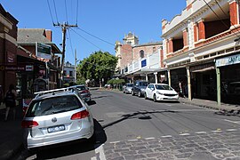
 Maling Road, Canterbury | |||||||||||||||
 | |||||||||||||||
| Coordinates | 37°49′30″S 145°04′41″E / 37.825°S 145.078°E | ||||||||||||||
| Population | 7,800 (2021 census)[1] | ||||||||||||||
| • Density | 2,600/km2 (6,700/sq mi) | ||||||||||||||
| Postcode(s) | 3126 | ||||||||||||||
| Elevation | 70 m (230 ft) | ||||||||||||||
| Area | 3 km2 (1.2 sq mi) | ||||||||||||||
| Location | 10 km (6 mi) from Melbourne | ||||||||||||||
| LGA(s) | City of Boroondara | ||||||||||||||
| State electorate(s) | |||||||||||||||
| Federal division(s) | Kooyong | ||||||||||||||
| |||||||||||||||
Canterbury is an eastern suburb of Melbourne, Victoria, Australia, 10 km from Melbourne's Central Business District, located within the City of Boroondara local government area. Canterbury recorded a population of 7,800 at the 2021 census.
Famed for its leafy green boulevards and substantial, opulent historic residences, Canterbury is one of Melbourne's most expensive and exclusive suburbs.
- ^ Australian Bureau of Statistics (28 June 2022). "Canterbury (Vic.) (Suburbs and Localities)". 2021 Census QuickStats. Retrieved 3 July 2022.
 Material was copied from this source, which is available under a Creative Commons Attribution 4.0 International License.
