Back كانتويل (ألاسكا) Arabic كانتويل ARZ کانتول، آلاسکا AZB Cantwell Catalan Кантвелл (Аляска) CE Cantwell CEB Cantwell (Alaska) German Cantwell (Alaska) Spanish Cantwell (Alaska) Basque کنتول، آلاسکا Persian
Cantwell, Alaska
Yidateni Na’ | |
|---|---|
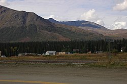
 Town of Cantwell, Alaska. Tracks for the Alaska Railroad run through the foreground. | |
 Location in Denali Borough and the state of Alaska. | |
| Coordinates: 63°23′17″N 148°54′1″W / 63.38806°N 148.90028°W | |
| Country | United States |
| State | Alaska |
| Borough | Denali |
| Government | |
| • Borough mayor | Clay Walker[1] |
| • State senator | Mike Shower (R) |
| • State rep. | Kevin McCabe (R) |
| Area | |
| • Total | 119.37 sq mi (309.16 km2) |
| • Land | 119.02 sq mi (308.26 km2) |
| • Water | 0.35 sq mi (0.91 km2) |
| Elevation | 2,190 ft (670 m) |
| Population (2020) | |
| • Total | 200 |
| • Density | 1.68/sq mi (0.65/km2) |
| Time zone | UTC−09:00 (Alaska (AKST)) |
| • Summer (DST) | UTC−08:00 (AKDT) |
| ZIP Code | 99729 |
| Area code | 907 |
| FIPS code | 02-10150 |

Cantwell (Yidateni Na’[3] in Ahtna Athabascan) is a census-designated place (CDP) in Denali Borough, Alaska, United States. As of the 2020 census, the population of the CDP was 200.
Cantwell is the western terminus of the Denali Highway. Once an Alaska Railroad flag stop at the junction with the Denali Highway, it was founded off the Parks Highway.
- ^ 2015 Alaska Municipal Officials Directory. Juneau: Alaska Municipal League. 2015. p. 5.
- ^ "2020 U.S. Gazetteer Files". United States Census Bureau. Retrieved October 29, 2021.
- ^ UAF: Alaska Native Place Names