Back Carnarvon Afrikaans كارنارفون (كاريبيرج لوكال مونيسيپاليتى) ARZ Carnarvon (kapital sa munisipyo) CEB Carnarvon (Südafrika) German Carnarvon (LAV) Estonian Carnarvon (Sudafrica) Italian Карнарвон (ЈАР) Macedonian Carnarvon (Noord-Kaap) Dutch Carnarvon NSO Carnavon Romanian
Carnarvon | |
|---|---|
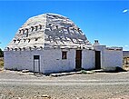
Top: View of Carnarvon, middle left: Dutch Reformed Misson House, right: Dutch Reformed Church, bottom left: Carnarvon Museum, right: Corbelled House. | |
| Coordinates: 30°58′S 22°08′E / 30.967°S 22.133°E | |
| Country | South Africa |
| Province | Northern Cape |
| District | Pixley ka Seme |
| Municipality | Kareeberg |
| Established | 1853[1] |
| Area | |
| • Total | 108.75 km2 (41.99 sq mi) |
| Elevation | 1,309 m (4,295 ft) |
| Population (2011)[2] | |
| • Total | 6,612 |
| • Density | 61/km2 (160/sq mi) |
| Racial makeup (2011) | |
| • Black African | 4.8% |
| • Coloured | 86.8% |
| • Indian/Asian | 0.3% |
| • White | 7.6% |
| • Other | 0.5% |
| First languages (2011) | |
| • Afrikaans | 96.2% |
| • English | 1.6% |
| • Other | 2.3% |
| Time zone | UTC+2 (SAST) |
| Postal code (street) | 8925 |
| PO box | 8925 |
| Area code | +2753 |
| Website | http://www.carnarvon.co.za/ |
Carnarvon is a small town in the Northern Cape Province of South Africa.


