Back Carrathool (rehiyon) CEB Carrathool Shire German Comté de Carrathool French Contea di Carrathool Italian Carrathool Shire Council Dutch Carrathool Shire Swedish
| Carrathool Shire New South Wales | |||||||||||||||
|---|---|---|---|---|---|---|---|---|---|---|---|---|---|---|---|
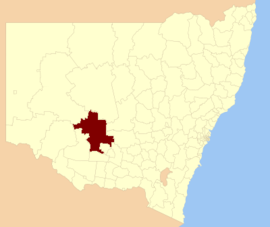
 Location in New South Wales | |||||||||||||||
| Coordinates | 33°58′S 145°42′E / 33.967°S 145.700°E | ||||||||||||||
| Population |
| ||||||||||||||
| • Density | 0.143615/km2 (0.37196/sq mi) | ||||||||||||||
| Area | 18,932.61 km2 (7,309.9 sq mi)[3] | ||||||||||||||
| Council seat | Goolgowi[4] | ||||||||||||||
| Region | Riverina and Far West | ||||||||||||||
| State electorate(s) | Murray | ||||||||||||||
| Federal division(s) | Farrer[5] | ||||||||||||||
 | |||||||||||||||
| Website | Carrathool Shire | ||||||||||||||
| |||||||||||||||
The Carrathool Shire is a local government area that borders both the Riverina and Far West regions of New South Wales, Australia. The Shire comprises 18,933 square kilometres (7,310 sq mi) and is located adjacent to the Mid-Western Highway and north of the Sturt Highway.
The largest town in the Shire is Hillston and the council seat is Goolgowi. The Shire also includes the villages of Merriwagga, Rankins Springs and Carrathool.
Where once regular droughts made life almost untenable, the area now has irrigated crops, gardens, greened sporting facilities and village verges. Over 15,000 square kilometres (5,800 sq mi) are now used in rural pursuits, including more than 600 square kilometres (230 sq mi) in wheat, rice, vineyards, cotton, potatoes, vegetables and orchard trees. Most of the change was made possible by the widespread use of river and underground water.[citation needed]
- ^ Australian Bureau of Statistics (27 June 2017). "Carrathool (A)". 2016 Census QuickStats. Retrieved 7 July 2017.
- ^ "3218.0 – Regional Population Growth, Australia, 2017-18". Australian Bureau of Statistics. 27 March 2019. Retrieved 27 March 2019. Estimated resident population (ERP) at 30 June 2018.
- ^ "Carrathool Regional Profile". Riverina Regional Development Board. Archived from the original on 20 July 2008. Retrieved 28 August 2008.
- ^ "Carrathool Shire Council". New South Wales Division of Local Government. Archived from the original on 29 July 2008. Retrieved 28 November 2008.
- ^ "Profile of the electoral division of Farrer (NSW)". Australian Electoral Commission. 25 February 2016. Retrieved 12 July 2016.