Back Καρριακού και Μικρή Μαρτινίκα Greek Kariakuo kaj Malgranda Martiniko Esperanto Carriacou y Pequeña Martinica Spanish Carriacou eta Martinika Txikia Basque Dépendance de Carriacou et Petite Martinique French Carriacou e Petite Martinique Italian カリアク島・プティトマルティニーク島 Japanese 카리아쿠 프티마르티니크 Korean Carriacou en Petite Martinique Dutch Карриаку и Малый Мартиник Russian
This article needs additional citations for verification. (March 2020) |
Carriacou and Petite Martinique Carriacou et La Petite Martinique | |
|---|---|
|
Flag | |
 Location of Carriacou and Petite Martinique | |
| Capital and largest city | Hillsborough 12°28.9′N 61°27.5′W / 12.4817°N 61.4583°W |
| Official languages | |
| Demonym(s) |
|
| Government | Part of Grenada |
• Monarch | King Charles III |
| Cécile La Grenade | |
| Dickon Mitchell | |
| Tevin Andrews | |
• Minister for Carriacou and Petite Martinique Affairs | Tevin Andrews |
| Establishment | |
• Part of British Grenada | 1763 |
• Constituency | 1944 |
• Part of Grenada | February 7, 1974 |
| Area | |
• Total | 37.7 km2 (14.6 sq mi) |
| Population | |
• Estimate | 6,081[1] |
| Currency | East Caribbean dollar (XCD) |
| Time zone | UTC−4 |
• Summer (DST) | UTC−4 |
| Drives on | left |
| Calling code | +1 473 |
| Internet TLD | .gd |
| |

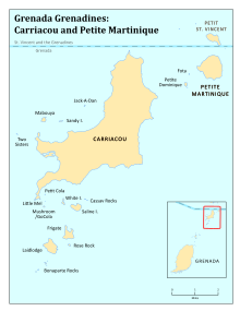
Carriacou and Petite Martinique, also known as the Southern Grenadines, is a dependency (part) of Grenada, lying north of Grenada island and south of Saint Vincent and the Grenadines in the Lesser Antilles.[2]
Carriacou Island is the largest island of the Grenadines, an archipelago in the Windward Islands chain. The island is 13 square miles (34 km2) with a population of 9,595 (2019 census). The main settlements on the island are Hillsborough, L'Esterre, Harvey Vale, and Windward.
The neighbouring island of Petite Martinique is 2.5 miles (2.2 nmi) away from Carriacou, and also a part of Grenada. With its 586 acres (2.37 km2) and population of 900, it is smaller than Carriacou. Carriacou and Petite Martinique are known for its Regatta and Village Maroon.
- ^ "GOV.gd: Grenada Government Official Web Portal - About Grenada, Carriacou & Petite Martinique". September 10, 2009. Archived from the original on 2009-09-10.
- ^ "Parishes of Grenada". Statoids.com. Retrieved March 3, 2020.
