Back Districte de Carrickfergus Catalan Carrickfergus District CEB Carrickfergus (distrikt) Danish Carrickfergus (Borough) German Borough de Carrickfergus French Comhairle Baile Charraig Fheargais Irish Distretto di Carrickfergus Italian 캐릭퍼거스구 Korean Carrickfergus (district) Dutch Carrickfergus (distrikt) NB
Carrickfergus Borough (historical)
| |
|---|---|
 | |
| Area | 82 km2 (32 sq mi) |
| Country | Northern Ireland |
| Sovereign state | United Kingdom |
| Councillors |
|

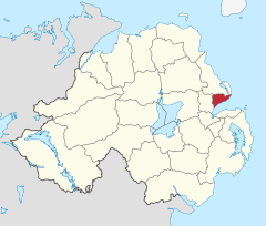
Carrickfergus Borough Council was a district council in County Antrim in Northern Ireland. It merged with Ballymena Borough Council and Larne Borough Council in May 2015 under local government reorganisation in Northern Ireland to become Mid and East Antrim Borough Council.
The council was based at Carrickfergus Town Hall and the council administered the town, on the north shore of Belfast Lough, and surrounding area, which extended from Greenisland in the south-west to Whitehead in the east. The borough was 32 square miles (83 km2), with a population of just over 39,000.
Together with the neighbouring district of Larne and small parts of Newtownabbey and Moyle, it formed the East Antrim constituency for elections to the Westminster Parliament and Northern Ireland Assembly.