Back بلدة كارولتون (ميشيغان) Arabic Carrollton (lungsod sa Tinipong Bansa, Michigan, Saginaw County, lat 43,46, long -83,94) CEB Carrollton, Michigan Welsh Municipio de Carrollton (Míchigan) Spanish ناحیه کارولتون، میشیگان Persian Carrollton (Michigan) Dutch Carrollton (Michigan) Portuguese Carrollton, Michigan Serbo-Croatian Каролтон (Мичиген) Serbian کیرولٹن ٹاؤن شپ، مشی گن Urdu
Carrollton Township, Michigan | |
|---|---|
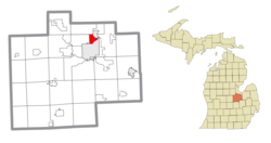
 Location within Saginaw County | |
| Coordinates: 43°27′34″N 83°56′22″W / 43.45944°N 83.93944°W | |
| Country | United States |
| State | Michigan |
| County | Saginaw |
| Established | 1866 |
| Government | |
| • Supervisor | Phillip Abney |
| Area | |
| • Total | 3.51 sq mi (9.10 km2) |
| • Land | 3.34 sq mi (8.64 km2) |
| • Water | 0.18 sq mi (0.46 km2) |
| Elevation | 587 ft (179 m) |
| Population (2020) | |
| • Total | 5,750 |
| • Density | 1,600/sq mi (630/km2) |
| Time zone | UTC-5 (Eastern (EST)) |
| • Summer (DST) | UTC-4 (EDT) |
| ZIP code(s) | 48604 (Saginaw) 48724 (Carrollton) |
| Area code | 989 |
| FIPS code | 26-13540[1] |
| GNIS feature ID | 1626035[2] |
| Website | Official website |
Carrollton Township (/ˈkɑːrəltən/ KAR-əl-tən) is a civil township of Saginaw County in the U.S. state of Michigan. The population was 5,750 at the 2020 census.[3] Established in 1866, Carrollton contains a full-time police department, fire department, parks and recreation services, as well as its own public school system, Carrollton Public Schools. Along with being located on the Saginaw River, Carrollton offers close access to shopping malls, medical facilities, Saginaw Valley State University, and I-75.
At only 3.34 square miles (8.7 km2) of land area, Carrollton Township is the fourth-smallest township in the state of Michigan, after Novi Township, Royal Oak Charter Township, and Pointe Aux Barques Township.
- ^ "U.S. Census website". United States Census Bureau. Retrieved January 31, 2008.
- ^ U.S. Geological Survey Geographic Names Information System: Carrollton Township, Michigan
- ^ "Explore Census Data". data.census.gov. Retrieved April 24, 2024.

