Back Municipio de Carryall Spanish Carryall udalerria, Paulding konderria (Ohio) Basque Município de Carryall Portuguese Xã Carryall, Quận Paulding, Ohio Vietnamese
Carryall Township, Paulding County, Ohio | |
|---|---|
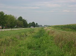
 An abandoned portion of the Wabash and Erie Canal in the township's southeast | |
 Location of Carryall Township in Paulding County | |
| Coordinates: 41°11′39″N 84°44′33″W / 41.19417°N 84.74250°W | |
| Country | United States |
| State | Ohio |
| County | Paulding |
| Area | |
| • Total | 36.3 sq mi (93.9 km2) |
| • Land | 35.6 sq mi (92.3 km2) |
| • Water | 0.6 sq mi (1.6 km2) |
| Elevation | 709 ft (216 m) |
| Population | |
| • Total | 3,010 |
| • Density | 84.6/sq mi (32.6/km2) |
| Time zone | UTC-5 (Eastern (EST)) |
| • Summer (DST) | UTC-4 (EDT) |
| FIPS code | 39-12308[3] |
| GNIS feature ID | 1086770[1] |
Carryall Township is one of the twelve townships of Paulding County, Ohio, United States. The 2020 census found 3,010 people in the township.
- ^ a b "US Board on Geographic Names". United States Geological Survey. October 25, 2007. Retrieved January 31, 2008.
- ^ "Carryall township, Paulding County, Ohio - Census Bureau Profile". United States Census Bureau. Retrieved August 4, 2023.
- ^ "U.S. Census website". United States Census Bureau. Retrieved January 31, 2008.