Back كهوف اجتيليك كارست و كارست السلوفاكيه ARZ Пячоры Агтэлекскага і Славацкага карстаў Byelorussian Пячоры Агцелецкага і Славацкага карстаў BE-X-OLD Pećine Aggteleka i Slovačkog krša BS Coves càrstiques d'Aggtelek i del Carst Eslovac Catalan Jeskyně Aggteleckého krasu a Slovenského krasu Czech Hulerne i Aggtelek Karst og Slovakiske Karst Danish Grutas kársticas de Aggtelek y del karst eslovaco Spanish Aggtelekeko haitzulo karstikoak eta eslovakiar karst Basque آگتلک و اسلوواک (مجموعه غار) Persian
| UNESCO World Heritage Site | |
|---|---|
 | |
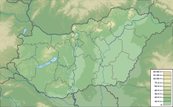
| Location | Hungary (H) and Slovakia (S) |
| Includes |
|
| Criteria | Natural: (viii) |
| Reference | 725ter |
| Inscription | 1995 (19th Session) |
| Extensions | 2000, 2008 |
| Area | 56,650.57 ha (139,986.6 acres) |
| Buffer zone | 86,797.33 ha (214,480.9 acres) |
| Coordinates | 48°28′33″N 20°29′13″E / 48.47583°N 20.48694°E |
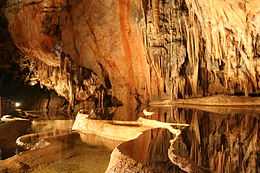
The Caves of Aggtelek Karst and Slovak Karst are a series of over 1000 karst caves spread out over a total area of 55,800 ha (138,000 acres) along the border of Hungary and Slovakia.[1] With an exceptional diversity of karst structures and complex cave systems developing from both temperate and tropical processes, the caves and surrounding areas were inscribed as a UNESCO World Heritage Site in 1995.[1]
- ^ a b "Caves of Aggtelek Karst and Slovak Karst". UNESCO World Heritage Convention. United Nations Educational, Scientific, and Cultural Organization. Retrieved 29 April 2023.

