Back سنترال، آرکانزاس AZB Metropolregion Little Rock German Área metropolitana de Little Rock-North Little Rock-Conway Spanish سنترال، آرکانزاس Persian سینٹرل آرکنساس Urdu
Central Arkansas | |
|---|---|
| Little Rock–North Little Rock–Conway, AR Metropolitan Statistical Area | |
From top to bottom: Little Rock, North Little Rock, Conway | |
 | |
| Coordinates: 34°44′10″N 92°19′52″W / 34.73611°N 92.33111°W | |
| Country | |
| State | |
| Principal cities | Little Rock North Little Rock Conway |
| Area | |
| • Urban | 669 km2 (258.3 sq mi) |
| • MSA | 10,580.6 km2 (4,085.18 sq mi) |
| • CSA | 18,519.2 km2 (7,150.31 sq mi) |
| Population (2022) | |
| • Urban | 461,864 (US: 89th) |
| • MSA | 748,031 (US: 81st) |
| • CSA | 912,604 (US: 62nd) |
| GDP | |
| • MSA | $47.322 billion (2022) |
| Time zone | UTC-6 (CST) |
| • Summer (DST) | UTC-5 (CDT) |
| Area code | 501 & 870 |
| Part of a series on |
| Regions of Arkansas |
|---|
 |
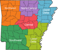
Central Arkansas, also known as the Little Rock metro, designated by the United States Office of Management and Budget as the Little Rock-North Little Rock-Conway Metropolitan Statistical Area, is the most populous metro area in the U.S. state of Arkansas. With an estimated 2020 population of 748,031, it is the most populated area in Arkansas. Located at the convergence of Arkansas's other geographic regions, the region's central location make Central Arkansas an important population, economic, education, and political center in Arkansas and the South. Little Rock is the state's capital and largest city, and the city is also home to two Fortune 500 companies, Arkansas Children's Hospital, and University of Arkansas for Medical Sciences (UAMS).
- ^ "Total Gross Domestic Product for Little Rock-North Little Rock-Conway, AR (MSA)". fred.stlouisfed.org.


