Back تشانليد سكابلنس ARZ Çanneld-Skablends Azerbaijani Channeled Scablands Catalan Channeled Scablands German Skablandoj Esperanto Scablands Spanish Channeled Scablands French Channeled scablands Scots/Gaelic הרמות המחורצות HE Channeled Scablands Italian
This article includes a list of general references, but it lacks sufficient corresponding inline citations. (February 2023) |

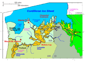
The Channeled Scablands are a relatively barren and soil-free region of interconnected relict and dry flood channels, coulees and cataracts eroded into Palouse loess and the typically flat-lying basalt flows that remain after cataclysmic floods within the southeastern part of Washington state.[1][2] The Channeled Scablands were scoured by more than 40 cataclysmic floods during the Last Glacial Maximum and innumerable older cataclysmic floods over the last two million years.[3][4][5] These floods were periodically unleashed whenever a large glacial lake broke through its ice dam and swept across eastern Washington and down the Columbia River Plateau during the Pleistocene epoch. The last of the cataclysmic floods occurred between 18,200 and 14,000 years ago.[6]
Geologist J Harlen Bretz defined "scablands" in a series of papers written in the 1920s as lowlands diversified by a multiplicity of irregular channels and rock basins eroded into basalt. Flood waters eroded the loess cover, creating large anastomizing channels that exposed bare basalt and creating butte-and-basin topography. The buttes range in height from 30 to 100 m (98 to 328 ft), while the rock basins range from 10 m (33 ft) in width up to the 11 km (7 mi) long and 30 m deep Rock Lake. Bretz further stated, "The channels run uphill and downhill, they unite and they divide, they head on the back-slopes and cut through the summit; they could not be more erratically and impossibly designed."[7]
The debate on the origin of the Scablands that ensued for four decades became one of the great controversies in the history of earth science. The Scablands are also important to planetary scientists as perhaps the best terrestrial analog of the Martian outflow channels.[8][page needed]
- ^ Bjornstad, B.; Kiver, E. (2012). On the Trail of the Ice Age Floods: The Northern Reaches: A geological field guide to northern Idaho and the Channeled Scabland. Sandpoint, Idaho: Keokee Books. ISBN 978-1879628397.
- ^ Neuendorf, K.K.E., J.P. Mehl, Jr., and J.A. Jackson, eds. (2005) Glossary of Geology (5th ed.). Alexandria, Virginia, American Geological Institute. 779 pp. ISBN 0-922152-76-4
- ^ Cite error: The named reference
Medley2012awas invoked but never defined (see the help page). - ^ Cite error: The named reference
Spencerothers2012awas invoked but never defined (see the help page). - ^ Cite error: The named reference
Bjornstad2002awas invoked but never defined (see the help page). - ^ Balbas, A.M., Barth, A.M., Clark, P.U., Clark, J., Caffee, M., O'Connor, J., Baker, V.R., Konrad, K. and Bjornstad, B., 2017. 10Be dating of late Pleistocene megafloods and Cordilleran Ice Sheet retreat in the northwestern United States. Geology, 45(7), pp. 583-586.
- ^ Baker, Victor (2010). Migoń, Piotr (ed.). Channeled Scablands: A Megaflood Landscape, in Geomorphological Landscapes of the World. Springer. pp. 21–28. ISBN 9789048130542.
- ^ Carr, M. H. (2006), The Surface of Mars. Cambridge Planetary Science Series, Cambridge University Press.