Back شابيه (كيبك) Arabic Chapais ATJ Chapais (lungsod) CEB Chapais German Chapais (Quebec) Spanish Chapais Estonian Chapais (Quebec) Basque شاپه، کبک Persian Chapais (Québec) French Chapais Polish
Chapais | |
|---|---|
 | |
| Coordinates: 49°47′N 74°51′W / 49.783°N 74.850°W[1][2] | |
| Country | Canada |
| Province | Quebec |
| Region | Nord-du-Québec |
| RCM | None |
| Settled | 1929 |
| Constituted | November 16, 1955 |
| Named for | Thomas Chapais[2] |
| Government | |
| • Mayor | Jacques Fortin |
| • Federal riding | Abitibi—Baie-James—Nunavik—Eeyou |
| • Prov. riding | Ungava |
| Area | |
| • Total | 62.40 km2 (24.09 sq mi) |
| • Land | 62.31 km2 (24.06 sq mi) |
| Population (2021)[4] | |
| • Total | 1,468 |
| • Density | 23.6/km2 (61/sq mi) |
| • Change (2016–21) | |
| • Dwellings | 711 |
| Time zone | UTC−05:00 (EST) |
| • Summer (DST) | UTC−04:00 (EDT) |
| Postal code(s) | |
| Area code(s) | 418 and 581 |
| Climate | Dfc |
| Website | www |
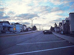
Chapais is a community in the Canadian province of Quebec, located on Route 113 near Chibougamau in the Jamésie region. It is surrounded by, but not a part of, the local municipality of Eeyou Istchee James Bay. The community was first settled in 1929, when prospector Léo Springer discovered deposits of copper, silver and gold in the area. Named for Thomas Chapais, it was incorporated as a city in 1955.[2]
- ^ "Chapais". Geographical Names Data Base. Natural Resources Canada.
- ^ a b c Cite error: The named reference
toponymiewas invoked but never defined (see the help page). - ^ a b Cite error: The named reference
mamrotwas invoked but never defined (see the help page). - ^ a b Cite error: The named reference
cp2021was invoked but never defined (see the help page).
