Back تشريفيلد (مين) Arabic تشريفيلد ARZ Cherryfield Catalan Черрифилд (Мэн) CE Cherryfield CEB Cherryfield, Maine Welsh Cherryfield (Maine) German Cherryfield (Maine) Spanish Cherryfield (Maine) Basque Cherryfield (Maine) French
Cherryfield, Maine | |
|---|---|
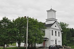
 Cherryfield Academy building, now housing town offices | |
| Coordinates: 44°36′36″N 67°55′46″W / 44.61000°N 67.92944°W | |
| Country | United States |
| State | Maine |
| County | Washington |
| Area | |
| • Total | 44.99 sq mi (116.52 km2) |
| • Land | 44.44 sq mi (115.10 km2) |
| • Water | 0.55 sq mi (1.42 km2) |
| Elevation | 118 ft (36 m) |
| Population (2020) | |
| • Total | 1,107 |
| • Density | 25/sq mi (9.6/km2) |
| Time zone | UTC-5 (Eastern (EST)) |
| • Summer (DST) | UTC-4 (EDT) |
| ZIP code | 04622 |
| Area code | 207 |
| FIPS code | 23-12455 |
| GNIS feature ID | 0582407 |
Cherryfield is a town in Washington County, Maine, United States on the Narraguagus River. It was named for the wild cherries that once peppered the banks of the river.[2] The town population was 1,107 at the 2020 census.[3] The town bills itself as the "Blueberry Capital of the World". Roughly 75 acres (300,000 m2) on both sides of the river are a historic district on the National Register of Historic Places known as the Cherryfield Historic District. This district comprises a collection of period structures dating from c. 1750–1890. The town was first settled about 1760. In 1826,the part of Steuben known as Narraguagus was annexed onto Cherryfield.
- ^ Cite error: The named reference
Gazetteer fileswas invoked but never defined (see the help page). - ^ "The Heart of Cherryfield - Down East Magazine - Maine". Archived from the original on 2009-01-06. Retrieved 2008-08-12.
- ^ "Census - Geography Profile: Cherryfield town, Washington County, Maine". United States Census Bureau. Retrieved January 21, 2022.
