Back تشيسترفيلد (نيوهامشير) Arabic بلده تشيسترفيلد ARZ Chesterfield (Nou Hampshire) Catalan Честерфилд (Нью-Гэмпшир) CE Chesterfield (lungsod sa Tinipong Bansa, New Hampshire) CEB Chesterfield, New Hampshire Welsh Chesterfield (Nuevo Hampshire) Spanish Chesterfield (New Hampshire) Basque چسترفیلد، نیوهمپشایر Persian Chesterfield (New Hampshire) French
Chesterfield, New Hampshire | |
|---|---|
Town | |
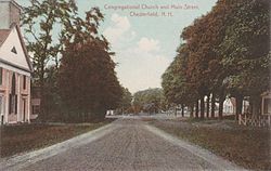
 Main Street in 1909 | |
 Location in Cheshire County, New Hampshire | |
| Coordinates: 42°53′14″N 72°28′13″W / 42.88722°N 72.47028°W | |
| Country | United States |
| State | New Hampshire |
| County | Cheshire |
| Incorporated | 1752 |
| Villages |
|
| Government | |
| • Board of Selectmen |
|
| • Town Administrator | Alissa Thompson |
| Area | |
| • Total | 47.5 sq mi (123.1 km2) |
| • Land | 45.6 sq mi (118.0 km2) |
| • Water | 2.0 sq mi (5.1 km2) 4.17% |
| Elevation | 853 ft (260 m) |
| Population (2020)[2] | |
| • Total | 3,552 |
| • Density | 78/sq mi (30.1/km2) |
| Time zone | UTC-5 (Eastern) |
| • Summer (DST) | UTC-4 (Eastern) |
| ZIP codes | |
| Area code | 603 |
| FIPS code | 33-12260 |
| GNIS feature ID | 0873565 |
| Website | www |
Chesterfield is a town in Cheshire County, New Hampshire, United States. The population was 3,552 at the 2020 census.[2] It includes the villages of Spofford and West Chesterfield. Chesterfield is home to Spofford Lake, Chesterfield Gorge Natural Area, and parts of Pisgah State Park and Wantastiquet Mountain State Forest.
- ^ "2021 U.S. Gazetteer Files – New Hampshire". United States Census Bureau. Retrieved November 3, 2021.
- ^ a b "Chesterfield town, Cheshire County, New Hampshire: 2020 DEC Redistricting Data (PL 94-171)". U.S. Census Bureau. Retrieved November 3, 2021.