Back نهر كيلكوتين ARZ چیلکوتین چایی AZB Chilcotin River CEB Chilcotin River German Río Chilcotin Spanish Chilcotin (rivière) French Chilcotin Italian Čilkotinas Lithuanian دریاۓ چلکوٹن PNB Чилкотин (приток Фрейзера) Russian
| Chilcotin River | |
|---|---|
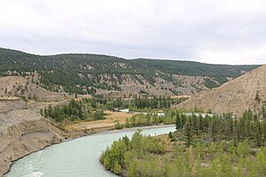
 Chilcotin in Farwell Canyon | |
 Chilcotin River watershed (Interactive map) | |
| Native name | Cheẑqox (Chilcotin) |
| Location | |
| Country | Canada |
| Province | British Columbia |
| District | Lillooet Land District |
| Physical characteristics | |
| Source | Itcha Lake |
| • location | Northeast of Itcha Mountain |
| • coordinates | 52°47′09″N 124°45′51″W / 52.78583°N 124.76417°W |
| • elevation | 5,223 ft (1,592 m)[1] |
| Mouth | Fraser River |
• location | Upstream from Gang Ranch |
• coordinates | 51°44′22″N 122°24′03″W / 51.73944°N 122.40083°W |
• elevation | 1,152 ft (351 m)[2] |
| Length | 241 km (150 mi) |
| Basin size | 19,300 km2 (7,500 sq mi)[3] |
| Discharge | |
| • location | below Big Creek[4] |
| • average | 102 m3/s (3,600 cu ft/s)[4] |
| • minimum | 13.8 m3/s (490 cu ft/s) |
| • maximum | 1,100 m3/s (39,000 cu ft/s) |
The Chilcotin River /tʃɪlˈkoʊtɪn/[5] located in Southern British Columbia, Canada is a 241 km (150 mi) long tributary of the Fraser River.[6] The name Chilcotin comes from Tŝilhqot’in, meaning "ochre river people," where ochre refers to the mineral used by Tŝilhqot’in Nation and other Indigenous communities as a base for paint or dye.[7] The Chilcotin River, Chilko River and Lake, and Taseko River and Lake make up the Chilcotin River watershed.[7] This 19,200 km2 (7,400 sq mi) watershed drains the Chilcotin Plateau which reaches north to south from the Nechako Plateau to Bridge River county and east to west from Fraser River to the Coast Mountains.[7][8] It is also one of twelve watersheds that make up the Fraser River Basin.[7] Made up of seven major tributaries, Chilcotin River starts northeast of Itcha Mountain, flowing southeast until it joins the Fraser River south of Williams Lake, 22 km (14 mi) upstream from Gang Ranch.[6][7]
The geological processes[9][10] that created this region support its diverse history, climate, and ecology. This diversity is also illustrated by the presence of biogeoclimatic zones and a rich population of fish.[11][12] Canadian Fisheries and many communities within the region such as: Alexis Creek, Hanceville, and the Tŝilhqot’in Nation depend on the diversity of Chilcotin River.[12][13][14] In recent years, its diverse history, climate, and ecology has been impacted by a number of environmental concerns such as: increases in flooding,[15] changes in water quality,[16] declines in steelhead trout populations,[17] and an increase in mountain pine beetle outbreaks.[18][19][20]
- ^ Source elevation derived from Google Earth.
- ^ Mouth elevation derived from Google Earth.
- ^ Benke, Arthur C.; Cushing, Colbert E. (2009). Field Guide to Rivers of North America. Academic Press. pp. 314–315. ISBN 978-0-12-378577-0. Retrieved 5 August 2013.
- ^ a b "Archived Hydrometric Data Search". Water Survey of Canada. Archived from the original on 24 December 2010. Retrieved 17 August 2013. Search for Station 08MB005 Chilcotin River below Big Creek
- ^ "A Guide to Aboriginal Organizations and Services in British Columbia 2011 / 2012" (PDF). Practice in BC. Archived (PDF) from the original on 2018-10-19. Retrieved April 13, 2020.
- ^ a b "BC Geographical Names". apps.gov.bc.ca. Retrieved 2021-04-14.
- ^ a b c d e "Fraser Basin Council - Fraser Basin Watersheds". fraserbasin.bc.ca. Retrieved 2021-04-14.
- ^ Giles-Hansen K, Wei X, Hou Y (March 2021). "Dramatic increase in water use efficiency with cumulative forest disturbance at the large forested watershed scale". Carbon Balance and Management. 16 (1): 6. Bibcode:2021CarBM..16....6G. doi:10.1186/s13021-021-00169-4. PMC 7923323. PMID 33646414.
- ^ Bevier, Mary Lou (2011-02-08). "Regional stratigraphy and age of Chilcotin Group basalts, south-central British Columbia". Canadian Journal of Earth Sciences. 20 (4): 515–524. doi:10.1139/e83-049.
- ^ Schiarizza, Paul (2013). "The Wineglass assemblage, lower Chilcotin River, south-central British Columbia: Late Permian volcanic and plutonic rocks that correlate with the Kutcho assemblage of northern British Columbia" (PDF). Government of British Columbia. Archived (PDF) from the original on 2019-08-29.
- ^ "Biogeoclimatic Zones of British Columbia". for.gov.bc.ca. Retrieved 2021-03-25.
- ^ a b "Fisheries – Tŝilhqot'in National Government". Retrieved 2021-03-24.
- ^ "Communities of BC's Cariboo Chilcotin Coast. Cities & Towns of the Cariboo Chilcotin and Central Coast of British Columbia". bcadventure.com. Retrieved 2021-04-14.
- ^ "Tsilhqot'in Select". River Select. Retrieved 2021-03-24.
- ^ "Hundreds stranded in communities as Chilcotin River flooding washes out roads | CBC News". CBC. Retrieved 2021-03-26.
- ^ Ministry of Environment and Climate Change Strategy (September 1, 2020). "New web reporting tool illustrates health of B.C.'s rivers". Government of British Columbia. Archived from the original on 2020-08-29.
- ^ Cite error: The named reference
:042was invoked but never defined (see the help page). - ^ Canada, Natural Resources (2013-10-25). "Mountain pine beetle (factsheet)". nrcan.gc.ca. Retrieved 2021-04-11.
- ^ Alfaro, René I.; Akker, Lara van; Hawkes, Brad (2015-06-04). "Characteristics of forest legacies following two mountain pine beetle outbreaks in British Columbia, Canada". Canadian Journal of Forest Research. 45 (10): 1387–1396. doi:10.1139/cjfr-2015-0042. hdl:1807/69663.
- ^ Cite error: The named reference
:82was invoked but never defined (see the help page).