Back Chiltern-Mount-Pilot-Nationalpark German Parque nacional Chiltern-Mt Pilot Spanish Parc national Chiltern-Mt Pilot French
| Chiltern–Mt Pilot National Park Victoria | |
|---|---|
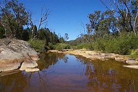
 Reedy Creek at Gladstone Track | |
 | |
| Nearest town or city | Chiltern |
| Coordinates | 36°07′59″S 146°36′04″E / 36.13306°S 146.60111°E |
| Established | 30 October 2002[1] |
| Area | 215.6 km2 (83.2 sq mi)[1] |
| Managing authorities | Parks Victoria |
| Website | Chiltern–Mt Pilot National Park |
| See also | Protected areas of Victoria |
The Chiltern-Mt Pilot National Park is a national park that is located in the Hume region of Victoria, Australia.[2] The 21,650-hectare (53,500-acre) national park is situated approximately 275 kilometres (171 mi) northeast of Melbourne, and extends west from Beechworth across the Hume Freeway and the Albury-Melbourne railway line to the west of Chiltern.[1][2]
The park was established under the National Parks (Box–Ironbark and Other Parks) Act, 2002 (Vic) to protect a diverse range of threatened species and ecosystems.[1][3] The distinctive features of the park include the Woolshed Falls, picturesque Mt Pilot summit, culturally significant Aboriginal rock art at Yeddonba and historical relics of the goldmining era scattered throughout.[1][4] The park is used for a number of recreational activities including bushwalking, hiking, trail riding, rock climbing, picnicking, camping, bird watching and prospecting.[1]
- ^ a b c d e f "Chiltern-Mt Pilot National Park Management Plan" (PDF). Parks Victoria (PDF). Melbourne: Victorian Government. 2008. Archived from the original (PDF) on 4 March 2016. Retrieved 8 April 2014.
- ^ a b Victoria's National Parks Explorer's Guide. Healesville: Parks Australia. 2001.
- ^ Durham, G. (2012). "Chiltern-Mt Pilot National Park". Park Watch (248): 26–27. Retrieved 15 April 2014.
- ^ Anderson, E. (2000). Victoria's national parks: a centenary history. Melbourne: Parks Victoria.
