Back جبال تشيزوس Arabic جبال تشيزوس ARZ Chisos Mountains CEB Chisos Mountains Czech Chisos Mountains German Montañas Chisos Spanish Monts Chisos French Chisos-hegység Hungarian Monti Chisos Italian Chisos Mountains LLD
| Chisos Mountains | |
|---|---|
 The Chisos Mountains as photographed facing southeast | |
| Highest point | |
| Peak | Emory Peak |
| Elevation | 7,825 ft (2,385 m) |
| Coordinates | 29°14′45″N 103°18′14″W / 29.24583°N 103.30389°W |
| Geography | |
| Country | |
| State | |
| Range coordinates | 29°16′N 103°18′W / 29.267°N 103.300°W |
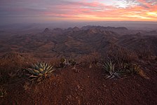
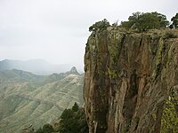
South rim sunset (left) and approaching rain (right)
The Chisos Mountains, also known as the Chisos, are a mountain range located in the Big Bend area of the Trans-Pecos region of Texas, United States.[1] The mountain system covers 40 square miles (104 square km) and is contained entirely within the boundaries of Big Bend National Park, making it the only mountain range in the United States fully contained within a national park.[1][2] The Chisos Mountains are the southernmost mountain range in the mainland United States.
The Chisos Mountains were created by volcanic activity during the Eocene Epoch 35-44 million years ago.[3]
The highest point in the Chisos Mountain range is Emory Peak at 7,825 ft (2,385 m) above sea level.[1]
- ^ a b c Kohout, Martin Donell. "Chisos Mountains". Handbook of Texas Online. Retrieved 2013-07-02.
- ^ Cite error: The named reference
:2was invoked but never defined (see the help page). - ^ Straight, William H. (May 1996). Stratigraphy and paleontology of the cretaceous-tertiary boundary, Big Bend National Park, Texas (Thesis thesis). Texas Tech University.


