Back الكنيسة وشارع ويلسلي Arabic Church and Wellesley German Church and Wellesley Spanish Church and Wellesley French Church and Wellesley Polish
Church and Wellesley | |
|---|---|
Neighbourhood | |
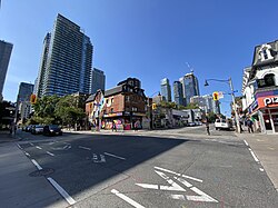
 View of the Village looking north from Church and Wellesley Street in 2023 | |
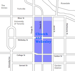
 Map of the neighbourhood. The office towers along Bloor are generally not considered part of the village | |
| Country | |
| Province | |
| City | Toronto |
| Government | |
| • Type | Ward 13 of Toronto City Council |
| • City councillor | Chris Moise |
| Area | |
• Total | 0.683 km2 (0.264 sq mi) |
| Population (2021)[1] | |
• Total | 26,163 |
| • Density | 38,306/km2 (99,210/sq mi) |
| Time zone | UTC-5 (EST) |
| • Summer (DST) | UTC-4 (EDT) |
Church and Wellesley is an LGBT-oriented enclave in Toronto, Ontario, Canada. It is roughly bounded by Gerrard Street to the south, Yonge Street to the west, Charles Street to the north, and Jarvis Street to the east, with the core commercial strip located along Church Street from Wellesley south to Alexander. Though some LGBT-oriented establishments can be found outside this area, the general boundaries of this village have been defined by the Gay Toronto Tourism Guild.[2]
- ^ GeoSearch
- ^ "Archived copy". Archived from the original on 2016-01-18. Retrieved 2013-11-17.
{{cite web}}: CS1 maint: archived copy as title (link)