Back تشيستيرنا دي لاتينا Arabic چیسترنا دی لاتینا AZB Cisterna di Latina BCL Чистерна ди Латина Bulgarian Cisterna di Latina Breton Cisterna di Latina Catalan Чистерна-Ди-Латина CE Cisterna di Latina (munisipyo) CEB Cisterna di Latina German Cisterna di Latina Esperanto
Cisterna di Latina | |
|---|---|
| Comune di Cisterna di Latina | |
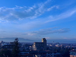
 View of Cisterna di Latina | |
| Coordinates: 41°35′27″N 12°49′42″E / 41.59083°N 12.82833°E | |
| Country | Italy |
| Region | Lazio |
| Province | Latina (LT) |
| Frazioni | Borgo Flora, Olmobello, Prato Cesarino, Le Castella, Doganella, Sant'Ilario-Castelverde, Isolabella |
| Government | |
| • Mayor | Valentino Mantini |
| Area | |
| • Total | 144.16 km2 (55.66 sq mi) |
| Elevation | 77 m (253 ft) |
| Population (31 July 2017)[2] | |
| • Total | 36,939 |
| • Density | 260/km2 (660/sq mi) |
| Demonym | Cisternesi |
| Time zone | UTC+1 (CET) |
| • Summer (DST) | UTC+2 (CEST) |
| Postal code | 04012 |
| Dialing code | 06 |
| Patron saint | St. Roch |
| Saint day | August 16 |
| Website | Official website |
Cisterna di Latina is a town and comune in the province of Latina in Lazio, of central Italy. It was the scene of the Battle of Cisterna in January 1944.
The Garden of Ninfa is located in the commune's territory.
The town, then known as Tres Tabernae ("The Three Taverns")[3] is mentioned in the Acts of the Apostles as one of the towns where Saint Paul stopped on his way to Rome.[4]
- ^ "Superficie di Comuni Province e Regioni italiane al 9 ottobre 2011". Italian National Institute of Statistics. Retrieved 16 March 2019.
- ^ "Popolazione Residente al 1° Gennaio 2018". Italian National Institute of Statistics. Retrieved 16 March 2019.
- ^ IAT Latina Tursimo, Itinerario Latina-Cori-Roccamassima-Ninfa-Norma-Sermoneta-Bassiano-Latina-Aprilia – Cisterna; accessed 2014.04.02.
- ^ Acts 28:15.


