Back نهر كلاكاماس ARZ Clackamas River CEB Clackamas French Клакамас (река) Russian Клакамас (річка) Ukrainian 克拉克默斯河 Chinese
| Clackamas River | |
|---|---|
 Clackamas River Bridge at Oregon City | |
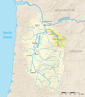
 Map showing the Clackamas River highlighted within the Willamette River watershed | |
| Etymology | Clackamas tribe |
| Location | |
| Country | United States |
| State | Oregon |
| Counties | Marion and Clackamas |
| Physical characteristics | |
| Source | near Olallie Butte |
| • location | Cascade Range, Marion County, Oregon |
| • coordinates | 44°49′17″N 121°47′47″W / 44.82139°N 121.79639°W[1] |
| • elevation | 4,909 ft (1,496 m)[2] |
| Mouth | Willamette River |
• location | Oregon City and Gladstone, Clackamas County, Oregon |
• coordinates | 45°22′21″N 122°36′31″W / 45.37250°N 122.60861°W[1] |
• elevation | 10 ft (3.0 m)[1] |
| Length | 83 mi (134 km)[3] |
| Basin size | 940 sq mi (2,400 km2)[4] |
| Discharge | |
| • location | 1.5 miles (2.4 km) northwest of Estacada, 23.1 miles (37.2 km) from mouth[5] |
| • average | 2,750 cu ft/s (78 m3/s)[5] |
| • minimum | 285 cu ft/s (8.1 m3/s) |
| • maximum | 86,900 cu ft/s (2,460 m3/s) |
| Type | Scenic, Recreational |
| Designated | October 28, 1988 |
The Clackamas River is an approximately 83-mile (134 km) tributary of the Willamette River in northwestern Oregon, in the United States. Draining an area of about 940 square miles (2,435 km2), the Clackamas flows through mostly forested and rugged mountainous terrain in its upper reaches, and passes agricultural and urban areas in its lower third. The river rises in eastern Marion County, about 55 miles (89 km) east-southeast of Salem. The headwaters are on the slopes of Olallie Butte in the Mount Hood National Forest, about 10 miles (16 km) north of Mount Jefferson, at an elevation of 4,909 feet (1,496 m) in the Cascade Range. The Clackamas flows briefly north and then flows northwest through the mountains, passing through North Fork Reservoir and Estacada. It then emerges from the mountains southeast of Portland. It joins the Willamette near Oregon City and forms the boundary between Oregon City and Gladstone.
The Clackamas provides hydroelectric power and drinking water for some of the Portland metropolitan area, and it supports runs of Coho salmon, spring and fall Chinook salmon, and summer and winter steelhead. The river's old-growth forests, its habitat for several species of birds, its healthy fish runs, and the recreational opportunities that it provides—such as fishing and whitewater rafting—led to the designation of more than half of the length of the river into the National Wild and Scenic Rivers System (NWSRS). This environment also allowed Native Americans to settle in the river's basin as early as 10,000 years ago.
Regulation of the river began in 1905 with the Cazadero Dam. In 1912, the River Mill Dam intercepted wood and coarse sediment. Later dams at North Fork, Oak Grove, Stone Creek, and Timothy Lake also intercepted wood sediment on the lower river.
- ^ a b c "Clackamas River". Geographic Names Information System. United States Geological Survey, United States Department of the Interior. November 28, 1980. Retrieved August 7, 2010.
- ^ Source elevation derived from Google Earth search using GNIS source coordinates.
- ^ Taylor, Barbara (1999). "Indian Use" (PDF). Salmon and Steelhead Runs and Related Events of the Clackamas River Basin: A Historical Perspective. Portland General Electric. Archived from the original (PDF) on March 11, 2006. Retrieved October 11, 2009.
- ^ "Tributaries". Willamette Riverkeeper. Archived from the original on November 10, 2013. Retrieved April 6, 2013.
- ^ a b "Water-data Report 2013: 14210000 Clackamas River at Estacada, OR" (PDF). United States Geological Survey. Retrieved September 11, 2015. Minimum discharge caused by filling of North Fork Dam forebay on October 5 and 6, 1958.
