Back Clearwater (lungsod sa Kanada) CEB Clearwater (British Columbia) German Clearwater (Colombie-Britannique) French Clearwater (Columbia Britannica) Italian Clearwater, British Columbia Swedish Клірвотер (Британська Колумбія) Ukrainian کلیئرواٹر، برٹش کولمبیا Urdu
Clearwater | |
|---|---|
| District of Clearwater[1] | |
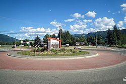
 Clearwater roundabout near Southern Yellowhead Highway | |
Location of Clearwater in British Columbia | |
| Coordinates: 51°39′N 120°02′W / 51.650°N 120.033°W | |
| Country | Canada |
| Province | British Columbia |
| Regional district | Thompson-Nicola |
| Incorporated | 2007 |
| Area | |
| • Total | 55.68 km2 (21.50 sq mi) |
| Elevation | 460 m (1,510 ft) |
| Population (2016) | |
| • Total | 2,324 |
| • Density | 42/km2 (110/sq mi) |
| Time zone | UTC−8 (PST) |
| • Summer (DST) | UTC−7 (PDT) |
| Postal Code | V0E |
| Area code | 250 / 778 / 236 |
| Highways | |
| Website | districtofclearwater |
Clearwater is a district municipality in the North Thompson River valley in British Columbia, Canada, where the Clearwater River empties into the North Thompson River. It is located 124 km (77 mi) north of Kamloops. The District of Clearwater was established on December 3, 2007, making it one of the newest municipalities in British Columbia. It is near Wells Gray Provincial Park and is surrounded by the Trophy Mountains, Raft Mountain and Dunn Peak.
- ^ "British Columbia Regional Districts, Municipalities, Corporate Name, Date of Incorporation and Postal Address" (XLS). British Columbia Ministry of Communities, Sport and Cultural Development. Archived from the original on July 13, 2014. Retrieved November 2, 2014.
