Back مقاطعة كليبورن (أركنساس) Arabic Cleburne County, Arkansas BAR Клейбърн (окръг, Арканзас) Bulgarian ক্লেবোর্ন কাউন্টি, আরকান্সাস BPY Cleburne Gông (Arkansas) CDO Клиберн (гуо, Арканзас) CE Cleburne County (kondado sa Tinipong Bansa, Arkansas) CEB Cleburne County, Arkansas Welsh Cleburne County (Arkansas) German Condado de Cleburne (Arkansas) Spanish
Cleburne County | |
|---|---|
 | |
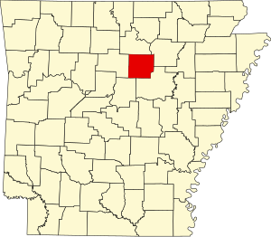
 Location within the U.S. state of Arkansas | |
 Arkansas's location within the U.S. | |
| Coordinates: 35°32′06″N 92°00′46″W / 35.535°N 92.012777777778°W | |
| Country | |
| State | |
| Founded | February 20, 1883 |
| Named for | Maj. Gen. Patrick Cleburne |
| Seat | Heber Springs |
| Largest city | Heber Springs |
| Area | |
• Total | 592 sq mi (1,530 km2) |
| • Land | 554 sq mi (1,430 km2) |
| • Water | 38 sq mi (100 km2) 6.5% |
| Population (2020) | |
• Total | 24,711 |
| • Density | 42/sq mi (16/km2) |
| Time zone | UTC−6 (Central) |
| • Summer (DST) | UTC−5 (CDT) |
| Congressional district | 2nd |
| Website | www |
Cleburne County (/ˈkliːbɜːrn/ KLEE-burn, historically /ˈkleɪbɜːrn/ KLAY-burn) is a county located in the U.S. state of Arkansas. As of the 2020 census, the population was 24,711.[1] The county seat and most populous city is Heber Springs.[2] The county was formed on February 20, 1883, as the last of Arkansas's 75 counties to be formed. It is named for Confederate Major-General Patrick Cleburne.[3] Cleburne is an alcohol prohibition or dry county.
- ^ "Census - Geography Profile: Cleburne County, Arkansas". United States Census Bureau. Retrieved January 19, 2023.
- ^ "Find a County". National Association of Counties. Archived from the original on May 31, 2011. Retrieved June 7, 2011.
- ^ Gannett, Henry (1905). The Origin of Certain Place Names in the United States. Govt. Print. Off. pp. 84.