Back Clemton Park (bahin nga lungsod) CEB کلمتون پارک، نیو ساوت ولز Persian Clemton Park Polish Clemton Park, New South Wales Romanian Clemton Park Swedish
| Clemton Park Sydney, New South Wales | |||||||||||||||
|---|---|---|---|---|---|---|---|---|---|---|---|---|---|---|---|
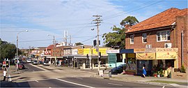
 William Street and Bexley Road intersection, in neighbouring Earlwood and adjacent to Clemton Park | |||||||||||||||
 | |||||||||||||||
| Population | 1,676 (2021 census)[1] | ||||||||||||||
| Postcode(s) | 2206 | ||||||||||||||
| Elevation | 27 m (89 ft) | ||||||||||||||
| Location | 13 km (8 mi) south-west of Sydney CBD | ||||||||||||||
| LGA(s) | City of Canterbury-Bankstown | ||||||||||||||
| State electorate(s) | Canterbury | ||||||||||||||
| Federal division(s) | Barton | ||||||||||||||
| |||||||||||||||
Clemton Park is a suburb in south-western Sydney, in the state of New South Wales, Australia. It is 13 kilometres south-west of the Sydney central business district in the City of Canterbury-Bankstown. The suburb is approximately bounded by Cup and Saucer Creek, Bexley Road in the east, William Street in the south and Kingsgrove Road, but excludes most of the properties which face onto those roads. Those properties are instead in the neighbouring suburbs of Earlwood, Kingsgrove and Campsie.
Clemton Park is a small suburb and almost entirely residential. Institutions, shops and facilities named or associated with "Clemton Park" are mostly situated outside the suburb boundaries: a small group of shops located at the intersection of Bexley Road and William Street, and Clemton Park Public School, are in the neighbouring suburb of Earlwood. Clemton Park Shopping Village is mostly situated within the suburb of Campsie.[2] The park named "Clemton Park" is situated in Kingsgrove.[3]
- ^ Australian Bureau of Statistics (28 June 2022). "Clemton Park (State Suburb)". 2021 Census QuickStats. Retrieved 9 August 2024.
- ^ Celmton Park Shopping Village – Centre Info
- ^ City of Canterbury-Bankstown, Clemton Park