| Cobblestone Mountain | |
|---|---|
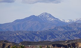
 View of the mountain's eastern face | |
| Highest point | |
| Elevation | 6,738 ft (2,054 m) NAVD 88[1] |
| Prominence | 1,373 ft (418 m)[2] |
| Listing | Sierra Club Hundred Peaks Section[3] |
| Coordinates | 34°36′32″N 118°52′04″W / 34.608982411°N 118.867853019°W[1] |
| Geography | |
 | |
| Location | Ventura County California, U.S. |
| Parent range | Topatopa Mountains Transverse Ranges |
| Topo map | USGS Cobblestone Mountain |
| Climbing | |
| Easiest route | Hike[3] |
Cobblestone Mountain is a peak in the Topatopa Mountains, in Ventura County, about 14 mi (23 km) north of Piru, California. At 6,738 feet (2,054 m), it is the highest peak of the Topatopa Mountains. Second highest is Hines Peak.[2] Snow frequently falls on the mountain during winter.
- ^ a b "Cobblestone". NGS Data Sheet. National Geodetic Survey, National Oceanic and Atmospheric Administration, United States Department of Commerce. Retrieved 2014-03-02.
- ^ a b "Cobblestone Mountain, California". Peakbagger.com. Retrieved 2014-03-02.
- ^ a b "Cobblestone Mountain". Hundred Peaks Section List. Angeles Chapter, Sierra Club. Retrieved 2014-02-23.
