Back کولن، لانکاشر AZB Colne (lungsod) CEB Colne Welsh Colne Spanish Colne Basque کولن، لانکاشر Persian Colne (Lancashire) French Colne Italian Colne (Lancashire) Dutch Colne NN
| Colne | |
|---|---|
 Colne, with its town hall on the horizon | |
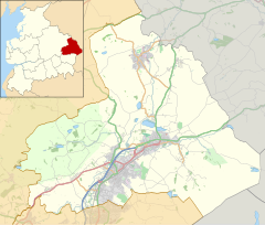
Location within Lancashire | |
| Population | 17,855 (2011 Census)[1] |
| OS grid reference | SD884399 |
| Civil parish |
|
| District | |
| Shire county | |
| Region | |
| Country | England |
| Sovereign state | United Kingdom |
| Post town | COLNE |
| Postcode district | BB8 |
| Dialling code | 01282 |
| Police | Lancashire |
| Fire | Lancashire |
| Ambulance | North West |
| UK Parliament | |
| Website | www |
Colne (/kɒln/[2]) is a market town and civil parish in the Borough of Pendle in Lancashire, England. The town is 3 miles (5 km) northeast of Nelson, 6 miles (10 km) northeast of Burnley and 25 mi (40 km) east of Preston.
The town should not be confused with the unrelated Colne Valley around the River Colne near Huddersfield in West Yorkshire.
Colne is close to the southern entrance to the Aire Gap, the lowest crossing of the Pennine watershed. The M65 terminates west of the town and from here two main roads take traffic onwards towards the Yorkshire towns of Skipton (A56) and Keighley (A6068). Colne railway station is the terminus of the East Lancashire railway line.
Colne adjoins the Pendle parishes of Foulridge, Laneshaw Bridge, Trawden Forest, Nelson, Barrowford and Blacko.
- ^ UK Census (2011). "Local Area Report – Colne Parish (1170215082)". Nomis. Office for National Statistics. Retrieved 23 February 2018.
- ^ Longman Pronunciation Dictionary s.v.

