Back Boscos de Comores Catalan Komoraj arbaroj Esperanto Selva de las Comoras Spanish Forêts des Comores French Foreste delle Comore Italian Коморские леса Russian Komor ormanları Turkish Коморські ліси Ukrainian
| Comoros forests | |
|---|---|
 Forest on Grande Comore | |
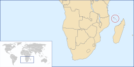
 Location of the Comoro Islands | |
| Ecology | |
| Realm | Afrotropical |
| Biome | Tropical and subtropical moist broadleaf forests |
| Geography | |
| Area | 2,100 km2 (810 sq mi) |
| Countries | |
| Coordinates | 11°45′S 43°24′E / 11.75°S 43.4°E |
| Conservation | |
| Conservation status | Critical/endangered[1] |
| Protected | 29.4%[2] |
The Comoros forests is a terrestrial ecoregion which covers the Comoro Islands, which lie in the Mozambique Channel between Madagascar and East Africa. These include four main islands: Grande Comore, Anjouan and Mohéli, of the Union of the Comoros, and Mayotte, a department and region of France.
These volcanic islands are rich in wildlife with endemic species including four endangered bird species living on Mount Karthala, the large active volcano on Grande Comore.
- ^ "Comoros forests". Terrestrial Ecoregions. World Wildlife Fund.
- ^ "Comoros forests". DOPA Explorer. Accessed 10 August 2021