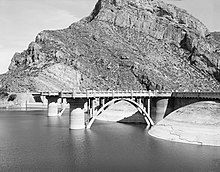
| Coolidge Dam | |
|---|---|
 Upstream face of Coolidge Dam, from Historic American Engineering Record | |
| Country | United States |
| Location | Gila County and Pinal County, Arizona |
| Coordinates | 33°10′29″N 110°31′40″W / 33.174687°N 110.527863°W |
| Status | Operational |
| Construction began | 1924 |
| Opening date | 1930 |
| Construction cost | US$10 million ($145 million in 2023 dollars[1]) |
| Owner(s) | Bureau of Indian Affairs |
| Dam and spillways | |
| Type of dam | Arch dam |
| Impounds | Gila River |
| Height | 249 ft (76 m) |
| Elevation at crest | 2,535 ft (773 m) |
| Width (crest) | 580 ft (180 m) |
| Dam volume | 200,000 cu yd (150,000 m3) |
| Spillways | 2 |
| Spillway type | Ogee |
| Reservoir | |
| Creates | San Carlos Reservoir |
| Total capacity | 910,000 acre⋅ft (1.12×10⁹ m3) |
| Power Station | |
| Commission date | 1935 |
| Decommission date | 1983 |
| Type | Conventional |
| Turbines | 2 × 5 MW |
| Installed capacity | 10 MW |
Coolidge Dam | |
| Area | 21 acres (8.5 ha) |
| Built | 1927 |
| Built by | Major C.R. Olberg; Atkinson, Kier Bros. & Spice Co. |
| Architect | Herman Neuffer |
| Architectural style | Multiple Dome Dam |
| NRHP reference No. | 81000135[2] |
| Added to NRHP | October 29, 1981 |

The Coolidge Dam is a reinforced concrete multiple dome and buttress dam 31 miles (50 km) southeast of Globe, Arizona on the Gila River. Built between 1924 and 1928, the Coolidge Dam was part of the San Carlos Irrigation Project. Coolidge Dam was named after the 30th US president, Calvin Coolidge and was dedicated by President Coolidge on March 4, 1930. The design and construction engineer was Herman Neuffer, who oversaw much of the construction undertaken by the Bureau of Indian Affairs (BIA) during the 1920s in Arizona and New Mexico.
Coolidge Dam impounds San Carlos Lake on the San Carlos Apache Indian Reservation. The project irrigates 100,000 acres (40,000 ha).
Since the water is impounded so it can be released when farmers need it, San Carlos Lake is often at a low level except in wet periods. When former President Coolidge dedicated the dam in 1930, the dam had not begun to fill. Humorist Will Rogers looked at the grass in the lake bed, and said, "If this were my lake, I'd mow it."[3]
- ^ Johnston, Louis; Williamson, Samuel H. (2023). "What Was the U.S. GDP Then?". MeasuringWorth. Retrieved 30 November 2023. United States Gross Domestic Product deflator figures follow the MeasuringWorth series.
- ^ "National Register Information System". National Register of Historic Places. National Park Service. 9 July 2010.
- ^ "Arizona scenic drive: Globe to Safford". Arizona Republic. 2 October 2015. Archived from the original on 22 September 2020. Retrieved 19 March 2016.


