Back Coonabarabran CEB Coonabarabran German Coonabarabran Esperanto کونابارابران Persian Coonabarabran French Coonabarabran Italian Coonabarabran Malagasy Coonabarabran Malay Coonabarabran Dutch Coonabarabran Polish
| Coonabarabran New South Wales | |||||||||
|---|---|---|---|---|---|---|---|---|---|
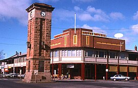
 Town centre/ Imperial Hotel | |||||||||
| Coordinates | 31°15′S 149°16′E / 31.250°S 149.267°E | ||||||||
| Population | 2,387 (2021 census)[1] | ||||||||
| Postcode(s) | 2357 | ||||||||
| Elevation | 505 m (1,657 ft) | ||||||||
| Location |
| ||||||||
| LGA(s) | Warrumbungle Shire | ||||||||
| County | Gowen | ||||||||
| State electorate(s) | Barwon | ||||||||
| Federal division(s) | Parkes | ||||||||
| |||||||||
Coonabarabran (⫽kuːnəbærəbrən⫽)[2] is a town in Warrumbungle Shire that sits on the divide between the Central West and North West Slopes regions of New South Wales, Australia. At the 2021 census, the town had a population of 2,387,[1] and as of 2021, the population of Coonabarabran and its surrounding area is 3,477.[3] Local and district residents refer to the town as 'Coona'. Coonabarabran is the gateway to the Warrumbungle National Park, Siding Spring Observatory and the Pilliga Forest.
- ^ a b Australian Bureau of Statistics (28 June 2022). "Coonabarabran (Urban Centre/Locality)". 2021 Census QuickStats. Retrieved 22 January 2024.
 Material was copied from this source, which is available under a Creative Commons Attribution 4.0 International License Archived 16 October 2017 at the Wayback Machine.
- ^ Macquarie Dictionary, Fourth Edition (2005). Melbourne, The Macquarie Library Pty Ltd. ISBN 1-876429-14-3
- ^ "2021 Coonabarabran, Census All persons QuickStats | Australian Bureau of Statistics". www.abs.gov.au. Retrieved 28 June 2022.
